Why thru hike?
Well, this year I was finishing what I’d started last year, but also – it was the singular thing that excavated me from a deep mental health funk.
I have also come to the conclusion that my previous description of thru hiking – as being a labour of love and pain that you wonder why you’re putting yourself through while doing, but miss terribly once done… is short-sighted.
It’s the beginning of a thru hike that can be painful, the first three weeks or so from my experience – which just happens to be the average length of time of each of my hikes.
But then? You get strong. Mentally and physically. Your body can handle more and more, and you work out the kinks or weak spots. The first few weeks, I believe, are when you’ll see any possible injuries flare up. And your mind gets used to the new routine. What you may have lamented before, doesn’t phase you anymore. And your brain may inadvertently says to itself, in a forcefully comic voice – I eat kilometres for breakfast!
And this is how I felt at the end of this particular hike – by the end I felt like I was just getting started. But alas, I’ll have to bottle that sentiment up and save it for next time.
Another one bites the dust.
This blog documents the journey and some key issues surrounding this year’s hike.
If you want more information on the prep that goes into a hike like this, you can check out my other thru hike blogs: the ECT and BT Part 1.
What’s In A “Thru Hike”?
To the thru hiker purist, how I hiked the Bruce Trail end to end might not be considered a “true thru hike”. I understand this in the sense that I did not do the whole thing in one trip. The whole campervan + cycling thing in addition to hiking makes it a little different also, and I wasn’t camping on trail or carrying all my supplies on my back. But I would argue that in a lot of the ways that count – each part of this hike looked and felt pretty similar (the whole hiking almost every day thing).
So I consulted various sources to see what they had to say about their trails and thru hiking. Here are some definitions/ perspectives that I found:
REI: “A thru hike is an end-to-end backpacking trip on a long-distance trail”.
Wikipedia: “The act of hiking an established End to End trail or long-distance trail with continuous footsteps in one direction. In the US, the term is most commonly associated with the Appalachian Trail (AT), the Pacific Crest Trail (PCT), and the Continental Divide Trail (CDT), but may also refer to other end-to-end hikes… [such as] the Great Divide Trail (GDT) in Canada.” … “Section hiking, on the other hand, refers to hiking a trail one section at a time, without continuity and not necessarily in sequence with the other sections or within one hiking season.”
AT: “We define a Thru Hike as a hike of the entire A.T. in 12 months or less. These 12 months are not restricted to a calendar year.”
CDT: “3,000 milers: The CDTC recognizes anyone who reports completion of the entire …Trail… a journey between the Mexican and Canadian Border along the Continental Divide. Issues of sequence, direction, speed, length of time or substitutes for the “official” route are not considered.”
Bruce Trail: “An End-to-End is the completion of the entire main Bruce Trail on foot. At 900 km long, this journey can be done over 30 days or several years.”
As you can see, the definition seems to vary depending on who you ask.
All things considered, there were definite trade offs in the way I did things.
I still had a pack on my back, but it was maybe half the size and weight. I got to sleep in my van – which gave more shelter and security, though I missed out on the amazing feeling of sleeping in a tent/outdoors (technically this is prohibited on the BT…). I didn’t have to hang a bear bag or be on guard for poison ivy and ticks when choosing an overnight spot to sleep (again, technically not supposed to do this on the BT, though people do, or stay at motels and B&Bs). And I did not have to rely on natural water sources as my only place to get water – I kept water in my van. I actually found that water sources weren’t that plentiful on the BT, but I’m sure it’s doable.
That said, instead of setting up and tearing down camp, I had to drive to and from trailheads, drive to pick up my bike, and line up overnight spots. That plus the cycling took some good chunks of time out of my day, which was especially significant in the fall when you’ve got less daylight hours to work with, making it tighter to get in big kilometre days. The cycling zapped a good bit of energy, and I believe heightens the risk of injury (last year I strained my groin). Leaving my van and bike while hiking increased the risk of theft. Having my van also afforded me the liberty to explore the areas I was passing through more than I could have otherwise.
All in all – I got from one end to the other and I did a lot of hiking!
False Start
I had originally planned on doing this hike in the Spring, before it got too hot. But I didn’t end up hitting the road until the end of June. I had been training this time around- running, cycling, and hiking in order to strengthen all the ways in which my body would be used, each muscle group. I could really feel the difference it made to be in good shape at the outset of the hike – it felt good. Prior to starting I had experienced some minor twinges of aching here or there in my left achilles, but was not too bothered at that point.
DAY 1
- 12km cycled
- 19.6km hiked
- 6th Line (km 13.7, Map 24) to 9th Sideroad (km 33.3, Map 25) at Duncan Crevice Caves Provincial Nature Reserve.
It was a decently warm, cloudy day, and I was suprised how easy it was to fall back into the routine of the hike. Almost like it was yesterday that I’d been doing the first half of the BT. The forests along this stretch were enjoyable, with a few challenging spots. And there was a “Trail Tales” box with a notebook for hikers to sign.

Day 2
- 9.4km cycled
- 21.8km hiked
- 9th Sideroad (km 33.3, Map 25) at Duncan Crevice Caves Provincial Nature Reserve to km 52.2, Map 26 + 2.5km hiking north along road to roadside parking in Kimberley (km 46.8) + 100m + 300m side trail.
The day began with a killer uphill stretch of cycling on dirt road. I got to pass through an area with huge erratics on my hike, as well as Kimberley, a cute little town (with a cute little pub). Old Baldy provided a good climb. Deer Flies were annoying. This was the day a tornado touched down not far from me (40km northwest, about two hours after I’d finished for the day), and I finished my hike just as some rain and a thunder storm were moving in.

Day 3
- 11.2km cycled
- 15km hiked
- Beaver Valley Ski Club (km 81.1, Map 26) to Sideroad 16C (km 91.9, Map 27) + there and back between km 81.1 and 79.5 + 1km
This was the super hot day (31C) and it made me want nothing more than to stand under a waterfall… Though I’m told that’s a hot spot for sewage and parasites. I was feeling in good spirits and figured endorphins must be kicking in. The ski hills made for quite the steep and long climbs. The end of the day brought a rainbow and some exhaustion and nausea due to the heat. I also had an ingrown toenail begin to cause issues, and developed my first blisters, one of which was under one of my toenails and kept building pressure. Because my hiking boots were old, I had gotten insoles to help with support, but they ended up causing rubbing on the back of my heel.

Day 4
- 30.7km hiked
- Parking at Hogg’s Falls (km 67.5, Map 26) I hiked a loop, to km 52.2, Valley Crossover Side Trail to km 79.5, and back to 67.5.
I had woken up feeling pretty hot and a bit nauseous from the previous day. It was an overcast, muggy morning. It was one of those days where you feel emotional on trail – probably because I had a big day planned, was already tired and not feeling well at the outset, and thru hiking just has a way of grinding you down.
Eugenia Falls was beautiful. I got to clear ALL the spider webs with my face. Mosquitoes proved to be a real nuisance – I was eaten alive – promoting the violent musings of my brain in reciting the intro lyrics to Eminem’s classic “Go To Sleep“.
But all in all, it was a memorable and successful day – my first ever 30+ km day! I finally understood why my Dad was not able to move after running marathons.
The end of day drive also proved interesting as I passed through Osprey Township, where I saw a horse-drawn carriage and what I assume were Mennonites.


Postponing
Ultimately, the twinge/ aching in my foot got worse and was developing into an injury, but that wasn’t the only reason I decided to postpone the rest of my hike.
There were a lot of thunderstorms happening – and if I’d learned anything from last year’s hike – it was to not take any chances getting caught in one of those. And that tornado had touched down nearby. Some tornado info: they are born out of thunderstorms, look for yellow/green/black skies, hail may fall, they usually occur in the afternoon/evening, and tornado season is approximately from April to September.
The mosquitoes had become a nightmare – perhaps that makes me sound like a wimp, but so be it – I’d rather be able to stop and take in my surroundings peacefully than be distracted by the incessant swarming of those buggers! It truly took away from the enjoyment of the landscape and hiking, and I wanted to enjoy this. Doing something you’re not enjoying for the sake of results or completion – that’s not enjoying the journey, and that’s the kind of life I want to avoid. It’s doing things for the wrong reasons.
We’d had a lot of rainfall over the Spring and that coupled with the rising temperatures and continued wet weather set the mosquitos up to proliferate quickly. I got a feel for how they tend to hang out in shaded woods, and wearing black clothing/ short clothing/ tight clothing catered to them. Mosquitoes can develop from egg to adult in just ten days in the right conditions (22-27C). And 10C seems to be the critical temperature, above which mosquito activity rises, and below which (consistently) they start to die off. Mosquitoes dislike dry areas, loose clothing, wind, and smoke. They like sweaty skin and sweet smells. Seeing as how I couldn’t shower and launder my clothes after every day of hiking, I wasn’t keen on covering myself in chemical-ridden bug deterrents. I had a natural bug repellant made with essential oils, but that was oily and the deterring scent didn’t last super long.
Finally, the weather had gotten hot. With the humidity the forecast was showing it to feel like it was 30C+. Hiking for long periods in these conditions zapped your energy quickly, could make you feel ill, and was a risk to your health.
But I got in a good chunk of the Beaver Valley section before calling it quits.
SUMMER TOTAL:
- Cycling: 32.6km
- Hiking: 87.1km
Foot Injury
A doctor (GP) took a look at my foot, said it was probably achilles tendonitis, and just told me to rest and it would get better. So I did some research of my own.
The conclusion I’ve come to is that it’s been a whole bunch of things wrong with my foot, and they may be chronic. I’ve been dealing with plantar fasciitis on and off since 2019. I seemed to have developed insertional achilles tendonitis – which is harder to get rid of than regular achilles tendonitis. And the area around the top of my heel bone has a pronounced bump – sometimes called a haglund deformity or a pump bump, which who knows – could be influencing bursitis. Because all of these areas are connected, the inflammation or tightness of one can affect the others.
Icing. The first thing I started to do after the false start was ice my foot. I did this 1-2 times a day, for about two months, especially after activities. But honestly, I’m not sure it helped.
Low Impact Exercise. Warm up, stretch before and after. Increase training slowly. Avoid running. I even avoided hiking and was only cycling to keep in shape, as I wanted to keep exercise low impact – and even after a bike ride my foot would flare up and ache. If I had access to a pool/ liked swimming, running in water would have been great.
Stretching with a focus on the plantar fascia, achilles tendons, and calves. It was important that I started my days with stretching so that I wasn’t moving around with tight muscles, straining them. I would bend back my toes and press down on the plantar fascia, the tendon running the length of the foot along the arch. I also have a massage ball that I roll along the bottom of my foot. The best stretch proved to be for the soleus calf muscle. In all my years of sports and running, I had never used this stretch – so it was no wonder my achilles was giving me problems as I surely had tight calves. When I first started this stretch it didn’t seem to being doing anything, but eventually, as I gained flexibility, I started to feel it. And let me tell you – after a day of hiking – stretching that muscle feels super good. Stretching the lower legs and feet were key daily practices to an injury free hike.
Eccentric Heel Drops. The only thing that really seemed to help the healing process and deliver results was eccentric heel drops. These are done to strengthen the area. Typically they are done with the balls of your feet on the edge of a step and you lower your heel below the level of the step you are on. But with insertional achilles tendonitis this can actually aggravate the area, so it is recommended to do a modified flat version – you just don’t do it on a step and lower your heel to the ground. It took about two months before I could do these without pain. At which point it is recommended to add weights (like a backpack). I never did this, but still reaped the benefits.
Basically, to do these heel drops you use your good foot only (this is important) to get on your tip toes, slowly transfer your weight so you are on the tip toes of your injured foot, then slowly lower yourself until you are standing with your heel to the ground. Repeat this in 3 x 15 reps, twice a day (or as much as can be tolerated). Do it with legs straight. Only stop if pain is severe. It is recommended to do these while wearing shoes. And I did find I was more supported and comfortable in shoes, though now that my injury is a lot better (I’d say I’m at 90%) my feet can go shoeless doing these with no problems.
I also added collagen (tendons are made largely of collagen) as a supplement to drinks and smoothies. There are many foods that can be supportive in healing such an injury (protein, omega-3s and vitamin C to help with inflammation, etc.). And I avoided putting any extra pressure on my injured foot.
After almost three months, I finally started to feel like my foot was making progress. Then, the time came for my autumn attempt at finishing the Bruce Trail – it was now or never. I had no idea how my foot would handle things, but I had to try. I decided to really listen to my body and start slow, taking rest days when my foot was feeling off.
Rob Gasbarro of Outdoor 76 along the AT said: “Justifying huge mileage increases is 100% the biggest contribution to hike-ending injuries. Hikers should be looking at nurturing their most vital piece of gear—themselves … I see barefoot hikers kill it every year. They wear no shoes and do fine because they’re respecting their bodies with incredibly low miles to start. Unbeknownst to them, they’re developing and managing proprioceptors, stabilizers, and responsibly building a bulletproof foot. Treat the first month as the beginning.”
Somehow – my foot made it through. I came to the conclusion that ice and rest are not enough to heal an injury – you need to strengthen the area (I’m sure this is well known, but the healing process is fairly new to me). And I believe that the hiking helped me to do this, got the blood flowing through the area, and ultimately did my foot good – as long as I didn’t push too hard.
During the hike I noticed a few things. There would typically be a kilometre I’d hit for the day where my foot would start bothering me – often around km 17. I also got twinges in various places around my foot – not just the achilles or plantar fascia – it could be around the outer base of the heel also. I noticed that going uphill was fine if I kept my heel to the ground, but if I pushed off from the balls of my feet – that strained things. It was really hard for me not to push myself – whether that be how many kilometres I got in in a day or taking rest days – but I listened to my foot, and when it started acting up I listened. It was better to get to the finish line slowly than to push so hard that I caused a re-injury and couldn’t finish at all. Big picture > immediate gratification. My patience was tested, that’s for sure.
Additionally, hiking on rocks or roads was hardest on my feet. And when my injured foot would start hurting before my good foot, I started to think that this was not necessarily warning of re-injury, but simply a sign of that foot tiring quicker, or perhaps being more prone to inflammation.
My daily routine consisted of heel drops and stretching, and I believe this is in large part what allowed me to finish. I also tried lymphatic drainage on my feet and lower legs, though this never became a daily thing.
*I am not a doctor. Everything I did to heal my foot was based on my own research. Please do your own research / consult a professional if you are injured.
New Shoes
Having a foot injury was the kick in the butt I needed to invest in new shoes. And having begun following several thru hikers on social media, all of whom wore trail runners, I decided I wanted to scrap the boot and try trail runners for myself. I did loads of research, narrowed down the specs I liked and what was available in stores near me, and set out to find the right pair.
Specs
Hiking boots or trail runners? A switch more and more people seem to be making. Typically, it is said that trail runners can last up to around 800km, while boots can go up to 1600km. Boots often run more expensive. They are also heavier, and that weight on your feet is estimated to be the equivalent of 4-6 times the weight on your back (e.g., 2lbs on your feet = 8-12lbs on your back). Rigid boots that don’t breathe are more likely to cause blisters.
Heel Drop. High drop or zero drop? Heel Drop is the difference in height of a shoe between the ball of the foot and the heel. Zero drop shoes are flat – they have no difference in height from front to back. So, zero drop = 0mm drop, low drop = 1-4mm, and standard drop = 7-10mm. Stack height is the height of the midsole, so for example, if you have a stack height of 32mm – 28mm, this gives a drop of 4mm. Shoes like Altras are known for zero drops, and they claim that this feature promotes a more natural gait. It is recommended that if you want to try zero drop shoes, you transition slowly from non-zero-drops. So – if you’re used to wearing an 8mm drop shoe, try a 6mm next time, then maybe a 3-4mm, before attempting 0mm. Zero drops are touted for taking pressure off the knees, so they may be good for people with knee problems. But they shift pressure to the lower leg, the calf/achilles. They also have less arch support. Since I was dealing with achilles tendonitis going into this hike, I knew right off the bat that zero drops were out for me. That said, I made a point of trying on the Altra Lone Peaks at my local MEC, and they absolutely felt distinctly different to walk in. My previous running shoes were an 8/9mm drop, so I was looking to stay in that standard drop range.

Rock Plate. To protect the feet from uneven terrain or sharp/narrow rock surfaces, and keep the foot from bending around these surfaces so much that it tires out.
Sole Traction. The thing about the material used on the sole is that durability and traction are at opposite ends of the same spectrum. It’s like how softer rubber tires on your vehicle grip wet/slippery surfaces better – but a softer rubber is not as durable. I’ve seen reviews on shoes where the soles that boast the best traction have people saying they wore down way too fast.
Cushioning. Some people like to feel the ground they’re walking on, others require a lot of cushioning to offset the effect of impact on the body – such as taking pressure off an achilles injury. I was interested in higher levels of cushioning. Also, some shoes, like the Hoka One One Speedgoat, use a tonne of cushioning instead of a rock plate. Note: too much cushioning may slow you down/ take away energy, like running in sand.
Support. I was looking for a shoe that had an adequate arch to support my plantar fascia. The right kind of support can also keep your foot in place to lessen the chance of rolling an ankle, if that is a concern for choosing trail runners over a robust hiking boot.
Stack Height. The height of the material between your foot and the ground. Minimalist shoes will have ~15mm or less stack height, while more cushioned shoes like Hokas are at ~30mm stack height.
Toe Box Width. Get into thru-hiking and you’re going to hear people talk about toe splay and the holy grail of wide toe boxes – Altras. The Altra Lone Peak is one of the most popular shoes among thru hikers (at least from what I’ve seen in the US), not only for its toe box, but for its zero drop shoes. It is said that the more one hikes, the more one’s feet seem to flatten and get wider. Toe splay, or the spreading of your toes as you walk, is good for balance, too.
Fit. Knowing what you want in the specs of a shoe is great, but that doesn’t mean it’s going to fit well. This was my issue – I knew what shoe I wanted (Brooks Cascadia) – but it just didn’t fit my foot well and I knew that would bite me in the ass. You don’t have to overthink fit too much – if it feels good, then great! But you don’t want your heel to be slipping (can try the heel lock lacing method), any pinching, noticeable seams that might cause rubbing, or your toe to hit the end of the shoe on an incline. You want a thumb’s width between your toes and end of the insole, and if you are laced up tight and still feel space above your foot, the the volume is likely wrong. Make sure the shoe flexes in line with where your foot flexes/bends. And you want to wear the same kind of socks (thickness) you plan on wearing while hiking when trying shoes on. I would be wary of advice to size up for thru hiking. It is commonly recommended to go half a size up from your regular size to allow for swelling of the foot on long hike days. So when I did this with my shoe purchase, I thought I had my bases covered. Turns out – the shoes were too big and I didn’t notice much swelling in my feet to compensate for this. I ended up wearing double & thick socks, but I still noticed my feet slipping inside the shoe on uneven terrain (maybe the volume was off) – a no-no for blister prevention. I also noticed that trying on the wide versions of shoes seemed to increase the volume of the shoes quite a bit. Thru Hikers typically like shoes that don’t need to be broken in and are good to go right out of the box.
Gore-Tex. A lot of trail running shoes offer Gore-Tex versions, which may be simply a liner, for waterproofing. This may sound like a good option for keeping your feet dry, but there are actually several reasons why I wouldn’t spring for this feature. It bumps the price of a shoe up (about $30 on the shoes I was seeing). Gore-Tex makes it likely that your feet overheat/ can’t breathe – because waterproofing tends to not only keep moisture out, but trap it inside as well.
You will see some shoes that note in the specs “drainage“, or someone will note this in the reviews – and this is also a useful feature so that if you do get wet, the water doesn’t just slosh around your foot.
Other specs to consider include dry time, gaiter attachment, weight, toe guard (you will kick the odd rock), upper material/mesh (is it a strong material that can resist tearing, is it a mesh that will let sand in), and getting professionally fitted (foot length, width, and arch measured).
In my research I reached out to an AT thru hiker I follow on Instagram, Sophia Garber, about picking shoes. She recommended getting professionally fitted and said that she used to wear boots but they were heavy and strained her achilles, and she was put into Brooks Cascadias, which solved all her problems.
I ended up going with La Sportiva Ultra Raptors because out of all the shoes I’d tried on, they fit the best. When researching the La Sportiva brand, I came across this article which was immensely helpful in narrowing down (no pun intended) some options that had a wider fit (this brand is known for having narrower shoes). Because La Sportivas are made with technical mountain terrain in mind, they sounded very appropriate for the rocky trails and escarpment of the BT.
La Sportiva Ultra Raptors:
- Rock guard instead of a rock plate (there were times I could feel the rocks underfoot more than I would have liked and I wonder how a rock plate would have differed).
- 7mm drop, satisfying my desire for a standard drop shoe (to keep pressure off the calves and achilles), while also having a slightly lower drop than I am used to – getting me a bit closer to zero drop should I want to gradually get there one day.
- Rubber outsole: I was very satisfied with the grip of the rubber outsole – a marked improvement over my previous Oboz boots. (I did love my Oboz – wore them till they fell apart – great arch support and super comfortable, but the stiffness gave way to blisters on long treks and traction wasn’t great).
- Absolutely durable: No visible degradation of the tread after 500km, no tears in the upper mesh, no separation of parts or seams.
- I could have used more arch support (to help support my plantar fascia).
- Sizing: Sizes run small, which was of no consequence to me as I wear men’s runners anyways. Sizes are also in European, which actually means you get some sizes between North American half sizes, giving a larger range to choose from.
- Narrow make: I found them to be a little narrower in the toe box than I would have ideally liked, with one seam against my pinky toe that I thought could rub, but this did not end up causing me any problems.
- Good quality.
- I didn’t have any issues breaking them in.
- Not waterproof, but I still found that my feet stayed fairly dry when it rained, and even after being submerged – they dried out fairly quickly.
- Cushioning: in terms of absorbing impact to take pressure off the PF and achilles – these were not the most cushioned shoes but worked well enough.
Besides having a size shoe that was a bit too big, I felt that the Ultra Raptors held up nicely.
And while it’s easy to get caught up on shoe specs and blame the shoes if we start to have foot or muscle/joint problems – we rarely give credit to the capabilities of our feet. A super strong, properly developed foot, can handle more. Indeed, by the end of my hike, my balance had improved and my feet felt… meatier.
My Experience
Trail runners beat boots for sure. Sophia Garber had said that the weight of her boots has caused her achilles issues, so I wonder if the weight reduction eased stress on my achilles also. From my experience, I liked these shoes. It did feel like they lost some of their cushioning/ support after 300-400km, which is sooner than I’d like. But they held up on the rocky terrain, had much better grip on wet surfaces than my old boots, and while I still got blisters – they were less painful than the ones I typically got in my boots – probably because runners are not as stiff.
Another thing I liked about these shoes was that even in the rain my feet didn’t seem to get wet. And after a couple of dunks under water – these shoes and my feet dried out fairly fast. There is nothing worse than feeling like you’re walking in puddles because your shoes hold water, and that was not the case for these shoes.

Bear Country
As I got closer to Owen Sound, I started to get fairly nervous about hiking solo in bear country. I grew up on the east coast of Newfoundland, where there are no bears. I had very little experience in bear country – let alone being in it alone. So, I was nervous. But when I start something, I finish it.
I talked to a few fellow hikers about bears. One said he hadn’t seen any this year on the Bruce Peninsula, but had come across one a couple of years ago. A pair of guys section hiking said they’d been in the National Park the day prior to meeting me and a bear had run out in front of them on trail. And another thru hiker from this year told me I had nothing to worry about. I was glad for the perspectives, but it didn’t change the fact that there was no predicting what experiences I might have, and I just had to get through it to get past it. I’d done my fair share of research and prep, and all I could do was be as bear wise as possible on trail. (That and not be an idiot – which is a common thought that flits through my mind on such treks).
A couple of people mentioned to me that bears are more of a risk in the Spring when they’ve just come out of hibernation and are pretty hungry. This is when encounters may be more of a risk, whereas in the Fall they’ve gotten several months of foraging under their belts to passify them.
I had bear spray in the side pocket of my pack, which lent some comfort, but I kept thinking that if I had a headwind, it would be of little use, as I wasn’t going to spray mace if it was just going to blow back in my face… That’s when I added a knife to my other side pocket. And honestly – that’s what really comforted me. I didn’t want to have to use it, but if a bear was coming at me and I couldn’t use the bear spray for whatever reason, at least I’d have something more than my useless trimmed fingernails against a bear’s teeth and claws.
I think the best thing I did to avoid an encounter was actually just making noise. I kept an eye out for signs of a bear (scat, prints, overturned rocks, tree wreckage) and would loudly clear my throat or call out if I felt the need. Having a headwind where a bear wouldn’t get your scent, in thick brush where a bear wouldn’t see you, near rivers that drown out the sound of your approach – all times to be vigilant. And while I have a bear bell – I echo what other hikers say – it is supremely annoying, so I didn’t use mine.
I felt pretty safe in open forest – where I could see a long ways around me, and bears would likely see me and have a clear escape route. I learned that even though some say bears are less likely to be found in open areas, they do frequent farmland – especially if there are apple trees nearby (and I passed a lot of apple tress, which were dropping their apples at this time of year – prime bear food).
I also liked how the fallen autumn leaves crunched under my feet, ensuring that I made plenty of noise. And I came to the conclusion that it was actually a plus to not smell fresh or good in bear country – not like freshly laundered clothes, perfume, or shampoo – which might attract a bear. I felt safer when I saw other people on trail, because it was likely that they had already alerted any bears that might have been in the area to human presence. It was the deserted sections that had me more on edge.
I carried a whistle and put pine essential oil on my pack each morning (I’d read that bears don’t like the smell of pine, though that seems odd, doesn’t it, since they live in forests). I put my food in an odour proof bag in my pack. And I used fragrance-free hand sanitizer. I also looked for bear notices regarding the areas I would be passing through.


Overnight Parking
I was worried about finding places to park overnight on this half of trail, but ultimately that uncertainty and discomfort pushed me to be resourceful. The main hurdle was the fact that southern Ontario does not have public/ crown land, and there are no Walmarts north of Owen Sound. Also, the Owen Sound Walmart will tell you that the landowner does not permit overnight parking for campervans and RVs and there are accounts on an app I use where people report being asked to move because of this. That said, I still saw RVs and campers that had clearly stayed the night – so some people do it anyway (I don’t believe there were prohibitive signs in the parking lot).
Walmarts had become a sort of comfort for me on this hike. I liked knowing where I was headed at the end of a long day, I could restock or grab breakfast in the mornings, and they had washrooms. Knowing that this would not be an option for the northern section of trail was a challenge, but one I’m thankful for. Because we do not grow when we are comfortable.
I stayed at a couple of campgrounds, mostly to do laundry and shower. But otherwise I actually “urban camped” most nights. I consulted various forums in the RV community and looked up town bylaws for street parking overnight, then scouted the areas to get a feel for them, check for signs, and make sure they felt safe. I settled on a few choice spots, and had no issues!
While hiking each day I made note of various trailheads that I felt I could get away with parking overnight at as well. Some even had porta-potties. As long as these trailhead lots had no signs that prohibited overnight parking, were somewhat enclosed by trees (to obscure view of my van from passing vehicles), and were not too close to private properties – I noted them as a possibility. Unfortunately, a large number of the BTC designated parking lots have signs prohibiting overnight parking. And there were a lot of signs to be found on the Bruce Peninsula in general that said no camping or overnight parking. This is one reason why I urban camped – and why I’m grateful that my van is pretty stealth – it looks more like a work van that a campervan, and so I feel like less of a target and like it is less likely for passersby to think someone is sleeping inside as opposed to just parking overnight.
Sometimes, van life requires that you take chances – and to be honest, there was always a feeling of pride waking up in the morning undisturbed. The trick to urban camping – be stealth. Make it seem like there is no one inside the van. I kept the front cab very clean, curtain drawn, and lights dim in the cargo area.


The Hike
I now walk into the wild

A Note on Rest Days
I took rest days throughout this hike. I might have taken one if my foot was protesting. Or I might have strategically taken them on days where the weather was bad – especially if it was calling for thunder and lightning. I paid close attention to the forecast and sometimes was able to plan my days around rain to avoid the worst of it, but there was no avoiding rain completely. I also used rest days to scout overnight spots, bathrooms, or to take in a town – like one day where I visited the Tom Thomson Art Gallery in Owen Sound and his resting place in Leith.
DAY 1
- 12km cycled
- 23.5km hiked
- Sideroad 16C (km 91.9, Map 27) to Griersville (km 113.6, Map 28) + 800m

I think the first day is the hardest, mentally. It’s nice to have fresh legs, but you also have the whole hike ahead of you, which can feel daunting. Long distance hiking really is a mental game, and so I’ve found that not thinking too far ahead and really trying to be in the present moment is helpful.
The day was sunny and warm (but not too warm), and I saw a praying mantis, snakes, and cleared plenty of spider webs with my body – yup, I was back on trail. I walked through the most serene field lined with wildflowers, and saw many an apple tree as well as other cool old trees.
This first day of the hike also happened to be my late father’s birthday, and I couldn’t think of a better way to start such a journey, as he was also an avid hiker and nature lover.

DAY 2
- 13km cycled
- 13.7km hiked
- Griersville (km 113.6, Map 28) to Rocklyn Creek Management Area (km 7.4 of the Sydenham Section, Map 29)
Another lovely day weather wise – I was getting temperatures hovering around 20C and today was sunny. There were some trees down on the trail from a recent wind storm, so I had to do some bushwacking to get around them and find the trail again. I passed a serene, peaceful waterfall dedicated to “beautiful gentle Anthea”, who’d died at the age of 23. My imagination conjured up a story of two young star-crossed lovers, and a man who visited this spot over the years, remembering the girl he loved.


DAY 3
- 10km cycled
- 17.5km hiked
- Rocklyn Creek Management Area (km 7.4, Map 29) to Massie Hills Management Area (km 24, Map 29) + 0.9km
This is the day it became apparent to me how much I dislike both cycling and driving on dirt roads. I focused on being present, patient, and appreciative of the nature around me. I was molding my mentality, building my working ethic, and fighting depression. Ultimately – this hike helped to break me out of a deep mental health funk this year. What I learned is that, at least for me, you have to force yourself to do the things that you know objectively you want to do, will bring you joy, and are good for you – despite your depressed or anxious brain telling you not to, or when you have zero motivation. Once you start doing, slowly you begin a cycle of positive reinforcement.
The cutest honey bee landed on my pack, which made me smile. And I began my pattern of playing music during sections of road walking. I was carrying a small bluetooth speaker in my pack side pocket, and found that the music, as well as singing along to it (there was usually no one around) – was great for upping motivation and passing the time.

DAY 4
- 16km cycled
- 17.8km hiked
- Massie Hills Management Area (km 24, Map 29) to Woodford (km 41.7, Map 30) + 0.1km
It struck me how lucky I was to spend my favourite season outdoors, in nature, witnessing in real time the changing of colours and falling of leaves.
I enjoyed the boardwalks through Bognor Marsh, and then succumbed to the muddy marshland that had overtaken the trail. The following trek through forest went up in elevation and became progressively more difficult, with more rocks on the trail, inclines, and the path overgrown in areas with some plants that may not have been poison ivy, but looked enough like it for me to be unsure and try my best to avoid touching them.
A habit that returned on this trek was keeping my hikes a “phone free zone”. Besides taking pictures, playing music, or the odd need of maps or something if I had service, I kept my phone on airplane mode and opted to use it as little as possible. Especially in terms of social media. And this boundary was great for mental health.
I met another solo thru hiker who’d started in Tobermory and was headed to Queenston. We chatted for a bit – it’s always nice to chat to fellow hikers. One thing that stuck with me from this convo was when he said that the peninsula section had “sucked”. In retrospect, I think he was just commenting on how it had rained on him a lot. But at the time I had taken it as general foreboding of what was to come. I had heard people say that the Peninsula section was the hardest section of hiking. And that paired with it being bear country and having the Massasauga Rattlesnake – was messing with my head a bit. In the end, I got over my fears and truly enjoyed the views on the Bruce Peninsula. I also had some better weather. So what I learned was: never take others’ words at face value, allow yourself the room to form your own opinions. It was absolutely a challenging section, but I ended up learning something about myself – I like a good challenge.
This was also a day where someone saw me peeing… From a distance at least. I seem to have horrible luck in this department. But it’s fairly funny in retrospect.
Finally, I popped my first blister.


DAY 5
- 27.7km hiked
- Woodford (km 41.7, Map 30) to Irish Block Road (km 64.9, Map 31) + 4.3km road walk back to km 41.7 to make a loop + 0.2km
I woke up with some stomach cramping that was a slight nuisance throughout the day, but did not cause major problems. I passed through a cool cave just north of Woodford Community Hall. And I was convinced that I’d touched poison ivy. While the plant looked like poison ivy, it might have been raspberry. I’m not convinced that there is not a plant that looks like raspberry but is actually poison ivy… as poison ivy can vary in appearance… But in the end I did not develop a rash, so I’ll take the win. I enjoyed Bayview Escarpment Provincial Nature Reserve.

This was also the first of many days where I would see something connected to Tom Thomson. I had no idea before now that Tom Thomson had grown up in the area of Owen Sound, and would come across trails named for him, commemorative plaques, signs for the cemetery he’s buried at, the Tom Thomson Art Gallery (I passed by it by mere fluke), and even a bridge and street named for the artist.
When I got back to my van, a guy who lives next to the Community Centre came up to me and we chatted a bit. Apparently hikers used to camp behind the building here, but recently a sign was put up prohibiting it. This guy was super friendly and seemed to go out of his way to help hikers when he could.

DAY 6
- 17km cycled
- 15.6km hiked
- Irish Block Road (km 64.9, Map 31) to 10th Concession Street (km 83, Map 31) *Due to the closure of the KOA property, some improvisation was required.
Despite feeling very tired after the previous day, I felt pretty good on this day’s bike ride. It rained a bit, but I enjoyed these sections of forest and escarpment. Other than cursing KOA for the closure, which put a crimp in my plans – it was an interesting and good day.


DAY 7
- 11km cycled
- 21.1km hiked
- 10th Concession Street (km 83, Map 31) to the Grey Bruce Tourist Info Office (west of km 104.4, Map 32)
This day proved challenging, but scenic, as I entered Owen Sound. I passed through some really great rock crevices and along some wonderful escarpment. Sometimes you’re just walking along the top of the escarpment, which will give you aerial views. But when you’re at the bottom you get a unique rocky experience, albeit the footing is usually more difficult. The section north of Inglis Falls Conservation Area was the most challenging – but the views made it worth it in my books. And Inglis Falls was beautiful.


DAY 8
- 10km cycled
- 17.9km hiked
- Grey Bruce Tourist Info Office (west of km 104.4, Map 32) to The Glen Side Trail (west of km 121.4, Map 33)
This was another enjoyable day of hiking, with a relatively easy bike ride. I got to walk at the base of the escarpment, between rock corridors, thinking about how this would be a prime place for a cougar to stalk me from above and pounce… “Fun” fact: while cougars/ mountain lions are found mostly in Northern Ontario, they have been spotted on the odd occasion south of Georgian Bay – an anecdote that my brain liked to hinge on at times on the trail. But usually, any fear was taken up by the more impending reality of the certain presence of bears.
And on that note – this was the first day where I saw scat that looked suspiciouly like bear. I was a wee bit surprised, as I was still close to the city and in a more densely populated area. But it was tubular, with what looked to be nuts.
I passed a group of four day hikers, one of which commented how she thought they were almost done, but was disappointed to find out they still had 4km left to go – out of a long 24km day. The gentleman passing me behind her, who I presume was her husband, commented under his breath, “nothing but complaints!” I couldn’t help but laugh, but it was a good reminder for me to not complain during my own trek. Perspective is everything.
The Georgian Bluffs Rail Trail was an enjoyable easy few kilometres, and I took the time here and on roads to listen to some podcasts. I finished the day at Jones Falls, which wasn’t fully visible from the main trail, but was lovely nonetheless.


DAY 9
- 13km cycled
- 14.5km hiked
- The Glen Side Trail (west of km 121.4, Map 33) to Lundy Road (km 135.2, Map 34)
It was one of those days where I had a hard time getting going, though once I did I found I wasn’t too tired. My blisters weren’t bothering me so much as that ingrown toenail. I saw more bear scat. And came across this bird – I believe it’s a dove – that damn near gives you a heart attack when you pass it, because at the last second it suddenly makes a bunch of noise and commotion to get away – probably scaring you more than you scared it. This bird would continue to make me jump out of my skin (as happens when you are already on edge about real predators) for the rest of the hike.

DAY 10
- 12km cycled
- 22.9km hiked
- Lundy Road (km 135.2, Map 34) to Colpoy’s Range Road (km 158.1, Map 34) including a designated re-route at the west side of Kemble Mountain Management Area
This was the day when my safety net of denial about bears was stripped away. A couple of kilometres into my hike I saw bear scat on the trail followed by a sign saying there was a bear in the area (~km 137-8). That’s the sort of thing that makes you feel exposed. There were apples on trail, so it wasn’t that surprising that a bear would frequent the area. I proceeded to call out in close intervals. Luckily, I did not encounter this bear.
Cloud cover gave way to sun, as snakes basked in the warmth of the light. Some of them I didn’t notice until they slithered away. This made me a bit weary as I thought of the possibility of catching the Massasauga by surprise. But I do love encountering garters on trail.
I also came across a very striking tree. It looked like it was stripped of all bark, dead and hollow, but still standing. I dubbed it the Skeleton Tree.

Like clockwork my feet started hurting around 17 km in. Toward the end of the day I came across a red Chevy Express with fan and solar installed on the roof, camped out on a narrow dirt road. I opted not to disturb the owner, but wished I could have chatted them up – having the same cargo van as me and doing the van life thing!
The final few kilometres back to the van were along a washed out road. I tried my best to skirt the edges of the massive puddles, in part bushwacking, but eventually I lost balance and one foot got submerged.


DAY 11
- 21km cycled
- 23.9km hiked
- Colpoy’s Range Road (km 158.1, Map 34) to Colpoy’s Bay (km 6.6, Map 35, Peninsula Section) just north of Wiarton + 1km
It was a hot, sunny day, that began with my bike ride on mostly flat terrain (always a bonus) – 21km cycled in 1hr15mins – which I was very happy with. This was the day I blared Pit of Fire by 3Teeth on repeat while cycling and road walking (the things that stick with you). I was beginning to feel my body hint at getting strong.
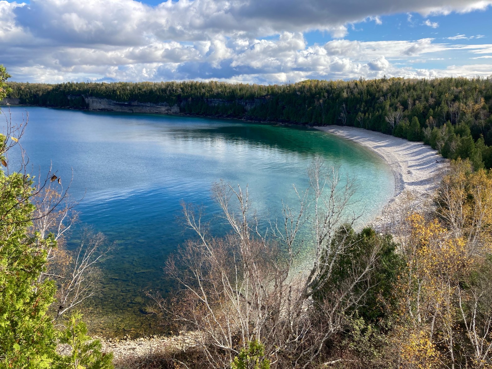
The trail took me right along the water, which I loved, down the coolest spiral staircase on the escarpment, by Wiarton Willie, the Wiarton Airport, Bruce Caves, and following the top of the escarpment which had – in my opinion – some of the best coastal views. All around – it was a great day.
As the first day on the coast since Niagara, I realized how much the change of scenery was boosting my excitement to be here, and how – while beautiful – the interior landscape of forest/farm/road for 750km had become a bit monotonous. I was beginning to appreciate how big a part views played in the enjoyment of such a hike. And while I was still fairly nervous about bears (the rattlesnake less so) – I figured, no risk = no reward – the chance of encounters was the price paid to be on this beautiful stretch of trail.
There is something about being on a coastline that just makes my heart sing. Perhaps it has to do with growing up in Newfoundland.


DAY 12
- 16km cycled
- 22.1km hiked
- Coveney’s Road (west of km 22, Map 36) to Hope Bay (km 44.1, Map 37)
Due to weather, I skipped ahead a bit to save a shorter day for a rainy day, as well as to fit the whole section of trail that passes through Neyaashiinigmiing (formerly Cape Croker) – lands of the Chippewas of Nawash Unceded First Nation – into one day. The BT Reference Guide states that vehicles are not permitted to drive through here, so I parked the van at the closest parking spots on either side of the border.
Hot tip: The Hope Bay parking area has a washroom – flush toilet and sink – very civilized. I assume the campground might operate it, as it was locked the second time I parked here, just after the camping season had ended.
I passed a box with a notebook for hikers to sign early in the day and was excited to see that a section hiker had passed through here same day – a guy had just started yesterday, hiking the Peninsula Section solo. I figured I wouldn’t see him as I taking rest days, but it was nice to know someone else was on the trail doing something similar.
There was an intense (and awesome) climb up the escarpment around km 36, after which I passed through fantastic forest. I almost walked up on a porcupine (he was none too pleased with me) and saw a few deer running through the trees. When you get into more secluded and preserved ribbons of wilderness I highly recommend stopping and taking it all in. It can be so quiet that you can hear your heart beat. No cars. No humans. Just you and nature. So peaceful. There is an authenticity to this level of wilderness that is really something, and this is why I would eventually be sad to leave bear country after reaching Tobermory – the bears were like markers that you were really in nature. It’s not your space, and there’s a respect that comes with that. But don’t let fear take over- be prepared, but enjoy the feeling of being part of nature.
Passing through this tougher terrain, my pace dropped below my average 4km/hr. I took this into account as I usually factored this in when planning my days, along with daylight hours. Roads I might be closer to 5kph, moderate terrain was likely around 4kph, and tough terrain perhaps 3.5kph.
Also, Hope Bay was quite pretty.


DAY 13
- 14km cycled
- 15.8km hiked
- Colpoy’s Bay (km 6.6, Map 35) to Coveney’s Road (west of km 22, Map 36)
While it had been calling for rain, it actually didn’t rain on me – which goes to show that you just never know with the forecast.
I had a bit of a scare at the beginning of the day when a cop car was tailing me. I didn’t think I’d been speeding… He was probably just putting the fear in me, as he eventually went another route.
I met two gentlemen who were working on finishing the Bruce Trail, a project they’d been doing for a few years I believe – as many people do. We chatted, and it was nice to connect with like-minded individuals. As we parted, one of them congratulated me – saying “you will finish”. And that was just the nicest thing.

DAY 14
- 9km cycled
- 22.9km hiked
- Hope Bay (km 44.1, Map 37) to Barrow Bay (km 67, Map 38)
One thing I like about the trail being on the coastline – you only have to look for bears to one side.
This was a challenging day. While I’d woken up on the wrong side of the… air mattress… I was in surprisingly good spirits on trail, despite the fact that I usually didn’t like when the trail was made of rocks, and it rained on me for the last half of the day. The rain turned out to be oddly comforting. And I came to realize that I like a challenge – climbing up and down the escarpment rock faces provided that. It provided excitement and a sense of accomplishment.
I could feel my endurance strengthening.
A bird made me involuntarily scream… so if I was to be surprised by a bear – I wondered how I would keep my cool…

DAY 15
- 10km cycled
- 21km hiked
- Barrow Bay (km 67, Map 38) to Forty Hills Road (west of km 87.5, Map 38/39), north of Lion’s Head
Well, it actually rained today. Luckily, it didn’t rain while I was cycling – cycling in the rain is the worst. But it started to pour as I started my hike. Not a problem – I had my rain jacket on and rain cover over my pack. As a wise man once said to me – there is no such thing as bad weather, only inappropriate clothing (or something to that effect). A guy even offered me a ride – but I told him I had to get my kilometres in. It was an on and off rain all day, with the sun coming out in between, and it even hailed for a bit! That freaked me out as I thought it might be signalling a thunderstorm – and I was right on top of the escarpment, on the edge of the cliffs and water, exposed to the high winds. I thought about the possibility of trees falling. The moody weather reminded me of Newfoundland.
At one point I absent-mindedly jumped off a rock, landing on my bad foot – and it handled the landing remarkably well – no pain. So that was a good sign.
I passed by a few glacial potholes, around 10,000 years old – getting a chuckle out of the “side trail” that was just 5m long, and loving the name “Giant’s Cauldron Pothole”.
Lion’s Head Harbour was really pretty, with what I presume was a father and son duo playing acoustic guitar and singing on the beach, with the sun shining after the rain – it was a really lovely thing to witness.
I finished the day on a road walk, into the wind and rain.

DAY 16
- 17km cycled
- 20.3km hiked
- Forty Hills Road (west of km 87.5, Map 38/39) to Borchardt Road (km 111.1, Map 40) + re-route of new main trail in Cape Chin
On my morning drive to the trailhead, I feel I was inducted into a whole new world of car lingo. A car coming toward me flashed their high beams thrice. At first I thought there might be something wrong with my van, and then it vaguely crossed my mind there could be cops in the area, so I drove hesitantly. Sure enough, there was a checkpoint up ahead with a cop car checking motorist speeds. I probably should have known, now I’m curious about other codes of the road…
By this point it was typical to see a lot of bear scat along the sides of the roads on my bike rides. I also started hitting sections of trail that took you onto white rock beaches. The new main trail through Cape Chin was visibly new, with plants recently cut back, but a very enjoyable section. I encountered two raccoons who immediately scurried up some trees upon seeing me, and I just smiled. I also saw fresh bear scat on the trail, and became extra vigilant, as the sun was getting closer to setting.
Another highly enjoyable day on the trail.


DAY 17
- 18.7km hiked
- Borchardt Road (km 111.1, Map 40) to Lindsay Road 40 (km 120.4, Map 40) there and back.
For reasons that will soon become obvious, Lindsay Road 40, along with Crane Lake Road, have become highly memorable roads for me.
Originally, the plan on this day had been to hike from Borchardt Road to the southern border of the Bruce Peninsula National Park at the end of Crane Lake Road, at km 127.9. But as I drove up Crane Lake Road that morning, the road narrowed, a sign said “Use At Your Own Risk”, and large patches of the road were completely washed out. Since I was not familiar with this road, I did not know how bad it might be. It was a rocky dirt road, and I’d come too far to risk Strider (my van) getting stuck – especially this far out in the middle of nowhere. Even if I had been comfortable driving in, the road was lined with bog, and there was no way I’d be able to skirt the edges of the washed out road – my feet would get wet (I suppose I could have taken my shoes and socks off). Ultimately, I played it safe and decided to change my plans. I would do there and back hikes moving forward, and I would cycle along this section of Crane Lake Road the next day – so my van wasn’t at risk and my feet would stay dry… This actually backfired in a couple of ways – but more on that later.
This day consisted of maybe one of my least favourite sections of trail – terrain wise. While it was a beautiful sunny day (which really brings out the blues of the water), the terrain was very very rocky, which slows you down and is tough on the body. There were also sections where so many leaves had fallen that you couldn’t tell what you were stepping on and it was like taking steps in the dark.
Devil’s Monument was a cool side trail to explore, with the rock formation, waterfall, and beach. There and backs also provide you with the opportunity to change things up and take some side trails.

DAY 18
- 15.6km cycled
- 28.2km hiked
- Lindsay Road 40 (east of km 120.4, Map 40) to Halfway Dump Side Trail (km 142, Map 41) in the Bruce Peninsula National Park, there and back
This is the day on trail that I will never forget. Things got interesting.
Story time.
So – I parked on Lindsay Road 40 and the plan was to cycle to the end of Crane Lake Road (km 127.9), do a there and back within the park, and then cycle back to the van at the end of the day. While cycling was supposed to keep my feet dry, the washed out areas of road were fairly deep and had big rocks, so with the resistance of the water and uneven ground, I lost balance and had to put a foot down – thus starting my day with a wet foot. Luckily, my shoes seemed to dry out pretty fast. It was also fortuitous that there was a man in a tractor filling the washed out sections of road to make it more passable (something I would be grateful for at the end of the day).

I began my hike with no issues. I was really excited to see a fresh, clear bear track in the mud (I had to check myself about being excited by this, but who am I kidding – it was pretty cool). I made excellent time on the trail leading to High Dump Campground/ the coast, after which the trail got pretty challenging – lots of “rock climbing”. I knew what time I needed to turn around in order to get back to my van before dark, with cushion time factored in, but I ended up pushing myself to go a bit further in order to reach a side trail, which would serve as my landmark for where to turn around the following day. It was a risk – using up my cushion time – but if I kept up the pace and had no unexpected issues, I should still make it back to the van by dark.


I made really good time on the way back, but when I got to my bike – I had a flat tire. Drat! My bike had been fine when I’d locked it up, but I guess it had gotten a slow leak. I didn’t have enough time to walk back to the van (at about 8km that could take almost two hours). So I had no choice but to change the inner tube. I disassembled the bike, but for the life of me could not find the source of the leak. There was no time to waste, so I just put everything back together without replacing the inner tube, pumped up the tire, and hoped for the best… By this time I had wasted most of the remaining daylight. I held my phone to the handlebars with its shitty flashlight on and began peddling (ironically, I had seriously considered getting a headlamp for this trek, but had decided against it).
All of the worst case scenarios flooded my brain, but in a situation like this adrenaline truly takes over – because you have no other choice but to keep going. Before long it was pitch dark. And I mean pitch dark. These were country roads, with houses few and far between. There were no streetlights. I was surrounded by forest. In bear country. I felt extremely vulnerable because I knew that me and my shitty flashlight were visible to anyone or anything nearby – but I couldn’t see beyond a few metres in front of me. A full moon was rising on the horizon, glowing orange as wisps of clouds floated across its face (who needs horror movies or kitschy aesthetics when you have real fear inducing situations like this one in October?). You would think – or hope – that a full moon would provide some illumination, but it was very very pale.
I worried that a bear could be on the road, and I wouldn’t know until I was right on top of it. Every once in a while I checked my faulty tire – it was soft but not flat and somehow holding up. I also periodically directed my shitty phone flashlight towards the woods on either side of me – one time I swear a set of eyes flashed as I did so…
This bike ride took forty minutes. After already having cycled that morning and pushed myself to hike 28km on some of the toughest terrain on the BT – I was tired. But I was going as fast as my body would allow. Forty minutes is a long time when you’re scared.
It occurred to me – what would I do if my van wasn’t where I’d left it? What if it had been stolen or towed? I kept cycling. And finally – finally – my van came into view. Oh, the relief. I quickly loaded up my bike and my pack. And as I was about to get in, I heard a rustling in the forest behind me… I whipped around – to see a fox trotting down the road.
As soon as I got into the van and locked the door, the state of shock and adrenaline began to recede, and I began to feel what I was actually feeling. My body began to shake, and I became emotional. My circuits must have been fried, as I couldn’t even listen to the radio on the drive to my overnight spot – it felt like too much for my senses.
This is the sort of experience you learn from. I wouldn’t want to relive it, but it certainly makes a good story. And as someone said to me – it builds character. Also, maybe it’s how we know we’re alive /feel alive.
Interestingly, I got this flat on the third last day prior to reaching Tobermory – and last year my flat tire occurred on the third last day of my hike also.


After the previous night’s ordeal, I needed a day off. On a previous rest day I had visited the Tom Thomson Art Gallery, so on this one I decided to visit Thomson’s resting place at Leith Historical Church. It felt like the perfect place for Thomson to be laid to rest – I of course did not know him, but it felt like a place such a man would like.
I grew up with prints of The Jack Pine and Northern River framed on my living room walls. A few years ago I visited Canoe Lake and the initial grave of Thomson with a friend. And this hike had brought him to the forefront of my mind.
In my trepidation regarding hiking solo through bear country, I’d come across the song “Courage” by The Tragically Hip (it had come on the radio). It became a song of encouragement for me. The Hip, of course, also have a song about Tom Thomson – Three Pistols. And so Thomson became a figure of inspiration for me throughout bear country also. Here was a man who appreciated nature so much that he dedicated his artistry to it and would go on grand treks through untouched wilderness. If he could do it – so could I. And whenever I felt the fear creep in, I reminded myself of Thomson, who seems to have joined the ranks of Chris McCandless for me in terms of outdoor inspirational figures. That – and I’d tell myself to not be a wimp. Sometimes fear serves a purpose and protects us, but the trick is to decipher when it is in fact holding us back.


DAY 19
- 26.2km hiked
- Halfway Log Dump (south of km 142, Map 41) to Sinkhole Side Trail (km 154.2, Map 42), there and back
This day covered the main, most popular attractions within the Bruce Peninsula National Park (BPNP), including The Grotto (a rock arch formation).
The rocky terrain up here, along the escarpment and on several rock beaches, began to wear on my foot, and I was getting twinges, with my foot becoming extra stiff and achy. This terrain also caused my knees to begin protesting.
This was the coldest day so far, at 8C.


DAY 20
- 14.3km cycled
- 24.2km hiked
- Sinkhole Side Trail (km 154.2, Map 42) to Tobermory (km 167, Map 42), some there and backs + tying up loose ends
The last day had come (sort of). It felt surreal that I would be getting to Tobermory today. And as I neared the completion of the Bruce Trail, my mind started mulling everything over. In order to qualify for official End to End recognition by the BTC, you had to have completed the whole trail on foot. And this brings me back to the cycling of Crane Lake Road biting me in the ass. Again.
I’m not one for leaving loose ends, and I certainly wasn’t going to chance disqualification as an end to ender. So I returned to the dreaded Lindsay Road 40… I cycled from east of km 120.4 to the National Park border at the end of Crane Lake Road for the third time, and then I walked my bike back to my van. I actually made great time – I was on a mission and power walking, completing the nearly 8kms in 90mins! I had my music blaring, and encountered a man dropping off his bike at Crane Lake Road – doing a similar trek to mine!
Once back at the van I drove to Tobermory to drop off my bike, then parked at the northern park boundary and did a there and back to Sinkhole Side Trail. This was a reasonably challenging hike, with beautiful views, and an incident that had me just as, if not more, fearful than my recent night bike ride…
Two guys were tailing me on the trail. While I had passed a few hikers on this section, I was getting deeper into the BPNP, and it sounded like the two men were gaining on me. As a female, alone in forest, with multiple males on my tail – I was nervous. Perhaps it was unfair of me to be fearful – they could be perfectly nice guys – but you can never be too careful. I was more nervous about this possible encounter than I had been in a while about potentially encountering a bear. I debated hiding in the woods and waiting for the guys to pass me. I had my bear spray and knife within reach in my pack side pockets. I reached my designated turnaround point, and decided to face these hikers. When it came time to pass them, I stepped to the side of the trail, and to my relief they simply smiled and said hello. I felt a bit bad about what had crossed my mind, while also continuing to put as much distance as I could between me and them. I can’t help but think about what it says about our society that I have such thoughts, and probably most women do.
Upon getting back to the van I then bee-lined it to Tobermory. These last kilometres on trail were lovely, passing through beautiful forests, on easier terrain than the BPNP, and right along the water’s edge. Despite it being chilly, I encountered a garter snake on the trail. He was moving in what seemed like slow motion, which makes sense – being cold-blooded – and it felt like he was bidding me farewell as I neared the completion of my trek ♡.
Reaching the Northern Terminus Cairn was surreal. I took lots of photos and walked around the harbour a bit before retrieving my bike and cycling back to the van.
I washed up and changed and decided to go to Tobermory Brewing Company to have a little celebratory meal. It was just too depressing to think of doing nothing to mark this occasion. While it was nice, I think next time I finish a trail I might camp out and watch the sunset, while enjoying a solitary beer of my own, with the companion that’s been with me all this way – Nature.


At this point, my Autumn trek tallied up at:
- Cycling: 231 km
- Hiking: 415.5 km
Because I had done 500km last Fall, I had it in my head that I wanted to reach that distance again this time around. I am pretty competitive with myself. And I think on some level I didn’t want the hike to be over. Plus, it gave me the chance to revisit a few of my favourite stretches of trail on my way back home.
But first – it was time to shower, do laundry, run some errands, and get a bit of rest. Which lined up perfectly with a couple of cold and rainy days – with a rain and flood warning in effect.
EXTRA DAY 1
- 27.1km hiked
- Black Bank (km 53.9 to km 47.5, Map 21) there and back
- Pretty River Valley (north of km 46.8, Map 23) to Nottawasaga Lookout Provincial Nature Reserve (km 42.9, Map 23) including Standing Rock & Caves Side Trail, there and back
- Pretty River Valley (km 46.8 to km 50, Map 23) there and back
There is a joy in revisiting favourite spots – no unknowns or having to do stretches that are boring or disliked. Being back in the interior, I noticed how the Bruce Peninsula didn’t have as many maple forests or drastic leaf colours. Perhaps it was the warm October that delayed the usual timeline for changing colours. I also realized that while the hills on the peninsula were short rock climbing, the valley sections were long trail climbs. Oh and also – the Blue Mountains had some of the most muddy areas I encountered on the whole BT.
It was a sunny day, and I was truly happy hiking this portion. Being back at some of my favourite spots – it was hard to tear myself away. I also witnessed a deer run across the road as I was driving in to Pretty River Valley – which made me smile.


EXTRA DAY 2
- 27.1km hiked
- favourite patch of forest in Pretty River Valley
- Hockley Valley (east of km 61.3 to km 49, Map 18), there and back
It’s funny how, when traversing the same places, you get memories from other times you were there come back. Even things I’d thought about last year came back to me.
The hills in this section were many and what I liked to call “quad killers”. I was surprised to see what looked like bear scat… And I started to realize what a shame it was that my hike was ending, when I finally felt like my body was strong and I had the desire to really start pushing my limits.


EXTRA DAY 3
- 31.7km hiked
- Hockley Valley Provincial Nature Reserve (east of km 61.3 to km 68, Map 18), there and back
- Limehouse (km 21.5 to km 24; km 21.5 to km 15.3, Map 12), there and backs
I had hoped to do my first ever 40km day – but it wasn’t in the cards with my foot, so I was happy to get another 30+ km day under my belt.
The maples are insanely tall in Hockley Valley Nature Reserve. It was quiet and peaceful, with no one around for most of the hike here. I saw a squirrel jump from one side of escarpment crevice to the other – skills.
Not long after starting the Limehouse portion of my hike it started to rain. I ended up getting pretty cold and wet by the end of it (also likely due to using all my energy stores) – so it was a luxury to be able to turn on the heat in my van and dry out/ warm up a bit.


OUTLIERS
Upon reflection, there were two short bits of trail that for whatever reason, I had bypassed last year. So I went back to finish them off:
- A loop near Brock University and Glenridge Quarry Naturalization Site, incorporating km 26.3 to km 30, Map 3 (Total: 5.3km)
- Twiss Road from km 97.9 to km 102.6, Map 10, there and back (Total: 9.4km)

Autumn Tally
- 231 km cycled
- 516.1 km hiked
Overall BT Trek Tally (Fall 2020 + June 2021 + Fall 2021)
- 562.5 km cycled
- 1,108.5 km hiked
Thoughts of a Thru Hiker
- Some of my favourite things: taking my shoes off at the end of the day, dinner, when all cleaned up and hunkered down in clean clothes at night.
- (From the summer false start) Sweating so much it’s like being in a sauna.
- It feels good to be strong.
- Prepare for weather forecasts, but don’t depend on weather forecasts.
- Spider webs in the eyes are the worst- and I mean web to eyeball. Another plus to autumn hiking – less webs, less bugs.
- “You pay in the coin of the realm” (mosquitoes as the price to pay for time in nature…).
- Autumn hiking surpasses summer hiking in that it has less bugs and you don’t sweat as much, which equates to you not feeling as dirty as fast.
- On a thru hike you realize how important rest, nourishment, and taking the time to take care of yourself means. Clean and bandage your feet so you don’t get an infection. Stretch so you don’t get an injury. Hydrate to prevent lactic acid and keep cool, and snack to keep your body going. Sleep and meals help your body heal and give you energy. Clean yourself and your clothes to boost morale. Socialize to boost morale. Appreciate the little things like a cool breeze or open trail (not bushwhacking), a roaring river or good traction on trail. It really makes you appreciative and grateful in life.
- Me in the van after a long day: “must move… don’t want to…”
- Each hike I seem to have a resident fly in the van with me, just the one… (are house flies territorial?)
- One thing about looking like a dork on a bike or a dirt bag (hiker trash) and not being freshly showered or wearing makeup is that you’re probably less likely to be preyed upon (by people).
- Noticing a pattern in chipmunks, squeaking and scurrying away when they see me coming. I’m sure it’s instinct, but I probably wouldn’t have noticed them if they hadn’t done that and just froze. I thought about predators- what if this is the chipmunks’ reaction because they are meant to have predators catch them… part of their purpose being to feed other animals.
- When you’ve been wearing the same clothes hiking for days and then switch to your other set of clean clothes and it makes a world of difference to morale.
- “I EAT KMs FOR BREAKFAST”.
- There is something special about the pain and grinding down of you on trail/ a thru hike that irons out your personal problems.
- Always a treat to find your van and bike haven’t been stolen/ broken into (knock on wood)!
- Not having hair would make cleanliness much easier.
- If not now – then when?
- I guess spooky season (hiking in October) IS a good time to be scared (bears).
- Not letting fear stop you.
- Sanitizer is a hiker’s best friend.
- If I ever started thinking “why am I doing this” (hard mental days on trail) – I reminded myself of how I might not have been able to/ how my Achilles could prevent me from finishing – and how LUCKY I am. I don’t “have to” – I “GET TO”!!!
- If I’ve learned anything from my injury, it’s that nothing in life is guaranteed, we take a lot for granted, and things can change at the drop of a hat which prevent us from being able to do certain things – so I am very grateful.
- Play music that gets you pumped up/ amped and remembering who the f*** you are (you got this).
- You may not have motivation, but just do it – force yourself to do the things you know objectively bring you joy – you’ll be happy you did.
- When I start something, I finish it.
- Nake Nula Waun (Lakota phrase: I am always ready, at all times, for anything).
- Would you rather get bit by a rattlesnake, mauled by a bear, or jumped by a cougar?
- “Pain is inevitable, misery is optional“.
- “The mind quits way before the body“.
- Ever wonder… when two paths diverge in the woods… if you’d be a different person had you taken the other path? Did your reality just split?
- “I be the witch of the wood” (The VVitch) and “a witch ought never to be frightened in the darkest forest, because she should be sure in her soul that the most terrifying thing in the forest was her” (Terry Pratchett).
- Discomfort promotes growth.
- I could be tired from working a 9-5 job all day/ week – or I could be doing this.
- It’s a marathon not a sprint.
- I think maybe those who are rewarded are those who try.
- Hiking is literally following the path of least resistance.
- Walking through bear country solo: badass or dumbass?
- Challenges to overcome on a long hike are what keep it from being boring or monotonous and it makes time go faster.
- Thought: everything is recycled. Like a mushroom in the forest that is squashed or broken- it will feed the earth; and our mishaps teach us lessons, feeding our own growth.
- Gosh does sun do morale a world of wonders.
- Forest smells best after a rain.
- You don’t get where you’re going by rushing, you get where you’re going by continuing to put one foot in front of the other.
- You have to get comfortable with being uncomfortable.
- I think hiking is so peaceful because it is meditative – it busies the mind – you are consumed with footing, looking out for poison ivy/ bears/ snakes, and attending to the basic functions of your body.
- It is not just the grip of your shoes, but inertia and the angle/ incline of your step, which determines whether you will slip.
- There is pleasure in the pathless woods (not always looking at your map or watch, which I had been guilty of, and found to promote an “are we there yet” attitude).
- Don’t hate on creatures in their natural habitat who could harm you – respect them – we are on their land, in their house.
- Watch the ground, watch the trees, watch for poison leaves… (rattler, bear, poison ivy).
- You truly have to push yourself out of your comfort zone in order to grow, let go, and embrace the new. Usually things I dreaded at the outset, became things I loved later on.
- Maybe bears come out at dawn to do their morning poo… maybe they do it on roads and trails because they don’t like brush hitting their bums, so prefer open spaces… (yes, I put thought into this).
- Me in the forest to everything I see: “you’re beautiful, and you’re beautiful, and you’re beautiful… you’re ALL beautiful!!!!!!”
- I’ve only myself to rely on out here… and that is a powerful feeling.
- It always baffles me that it takes 20 minutes by van to do what it takes 5 hours to hike… so why do it? Because of the views, because it’s there, because it means something.
- “Biomimicry” – when things in nature exhibit parallels to / lessons for humanity.
- Bears are like ghosts – it’s okay knowing they’re there as long as you don’t see them with your own two eyes, but the moment you actually see one you’re more scared.
- “Beast mode engage” – me, literally jumping rock to rock.
- The trail can look markedly different going in the opposite direction. Or in different weather for that matter.
- Did I see a bear ? No. But I think the real question is: did a bear see me?
- If you’re not gonna take in the views on a hike, then what are you in it for? (Views also boost morale).
- I am paradoxical, in that sometimes I seem to cling to comfort, but I also think I do well in adversity – the wet and cold feel like home to me… Probably due to growing up in Newfoundland.. Plus cliffs feel familiar, as if the roughness is relatable.
- Forcing things ruins things.
- I feel more at peace with myself with this hike under my belt, like I have worth.
- Your preferences will change over the course of a hike – e.g., wanting roads or short trails vs long uninterrupted bouts of trail – to support morale and mentality.
- As a hiker, I have never understood the need for trekking poles… it’s just something else to carry, they’re expensive, and what about rocky climbs?
- Nothin’ like a good mossy rock to make me swoon.
- You get to a point where hiking daily just feels natural, like “this is what I do now”.
- You don’t get strong overnight, but with every single step along the way.
- “How lucky am I to have something that makes saying goodbye so hard“.
Hike Soundtrack
Some of these are self-explanatory, if you listen to the lyrics, as to why they’d be on a hiking playlist. Others were ones I heard on the radio or held personal meaning to me and just stuck as reminders of this journey. I also compiled them all into a Spotify Playlist.
- The Chant – Gojira
- Pit of Fire – 3Teeth
- Go With The Flow – Queens of the Stone Age
- Would – Alice In Chains (Grunge Bible on Instagram has a running joke of posting this song all the time, and on a particularly slow morning when I did not want to get up, their post read: “I know some of you are waking up tired and sore. You can do it. Let’s get some AIC blaring and have ourselves a day! Try and see it once my way!!”)
- Amazonia – Gojira
- Go To Sleep – Eminem (listen to the intro and imagine it talking about swarms of mosquitoes attacking you… gets me every time)
- Paralyze – 3Teeth feat. Ho99o9
- Hold On – Royal Blood (“Nothing easy’s worth doing”)
- All My Favorite Songs – Weezer
- Pumped Up Kicks – 3Teeth
- I Don’t Mind The Pain – Danzig
- 50 Million Year Trip – Kyuss
- Hour of Deepest Need – Ezra Furman
- Courage – The Tragically Hip (entering bear country…)
- My Church Is Black – Me And That Man
- Here I Go Again – Whitesnake (“Here I go again on my own, goin’ down the only road I’ve ever known”)
- How You Remind Me – Nickelback (forgive me, but this one has personal connotations, and is fitting for a hike: “are we having fun yet“?)
- Ty Cobb – Soundgarden
- 3’s & 7’s – Queens of the Stone Age
- EXXXIT – 3Teeth
- Fly Again – Turnstile
- Hey Joe – The Jimi Hendrix Experience
- The Outlaw Josey Wales – One Bad Son (“sun down on a life before”)
- Lovin’ Every Minute Of It – Loverboy (I also need to apologize up front for this one – do yourself a favour and don’t watch the music video – but it had come on the radio while driving and the chorus/ title got stuck in my head, and in the context of boosting morale while long distance hiking – it fit).
- Barracuda – Heart (female empowerment)
- Boiler – Limp Bizkit
- Keep Your Eyes Peeled – Queens of the Stone Age (when you see bear scat)
- Ballad of Dwight Fry – Alice Cooper
- Bobcaygeon – The Tragically Hip
- Ordinary Day – Great Big Sea
- Wanted Dead or Alive – Bon Jovi (channelling Dean Winchester on the road)
- Don’t Stop Me Now – Queen (This came on the radio post-Tobermory, when revisiting favourite spots, and feeling like I was getting to the point on this hike where I wanted to push my limits, but the hike was ending…)
- Middle of Nowhere – Big Wreck (“The middle of nowhere is calling me home” was especially moving as I left the Bruce Peninsula)
- End of Me – Billy Talent
- Why Do All Good Things Come To An End – Nelly Furtado
Final Thoughts
Bear’s lesson: I dreaded entering bear country, going from the comforts of non-bear country to something new and scary and hard… which I think draws a general parallel to life. In the end I was sad to leave bear country. And I want to hold onto this feeling. I want to DO the hard things, the things I resist, and know that I will be happier for it.
Others’ opinions: It doesn’t matter what anyone else tells you or says – at the end of the day you have to make up your own mind. You are a completely different person, with different experiences, and a different way of seeing the world. And there is no predicting what circumstances you will face. Temper curiosity and reserve discovery for yourself in real time.
And here are some additional articles that I found useful:
- 5 Tricks to Successfully Thru Hiking
- Stretches for Cyclists
- 8 of the Best Stretches for Thru-Hikers
- Park4Night – a useful sight in looking up overnight parking options
- Identifying Poison Sumac vs Staghorn Sumac
- Hiking Solo In Bear Country
- Homemade Wanderlust – Dixie’s whole page has a wealth of info, but her documentaries of her triple crown are fun to watch.
- Public Washrooms in Bruce County
- HIKER TRASH (this one is merely for pleasure)

Future Directions
It has become apparent to me that this is something I do now. Hiking is a part of me, and thru hiking is something I will continue to pursue. I have been extremely fortunate in the past few years to do the treks that I have. And if my body allows it, I want to do more.
Nothing in my life is ever set in stone, so who knows where I’ll end up next. But I have my eye on the Great Divide Trail. It’s 1,100km along the BC and Alberta border. Due to the presence of Grizzlies and Mountain Lions – I will want to do this in a group. I also want to do it continuously, in one trip, which would make it my longest single trek to date (no cycling this time – hoorah!).
Beyond that, I’m sure there are other trails within Canada I could check out. But I think it would be an amazing long term goal to tackle the US Triple Crown (AT + PCT + CDT). And perhaps check out Europe or New Zealand – where the lack of wildlife dangers is a plus.
Until next time,
Kat
Copyright © 2021 Chronic X-Roads. All Rights Reserved.
