Introduction / Moving Forward
It’s been over three years since I’ve written here.
In a way, I became my own ghost. Sometimes you take detours in life. But I’m looking to do more writing now, and I want this blog to be a sort of portfolio and container. I want to archive my experiences, as I close a chapter and begin a new page.
Nobody tells you that you might need a period of decompression after constantly moving from place to place, constantly adjusting, constantly committing new things to memory.
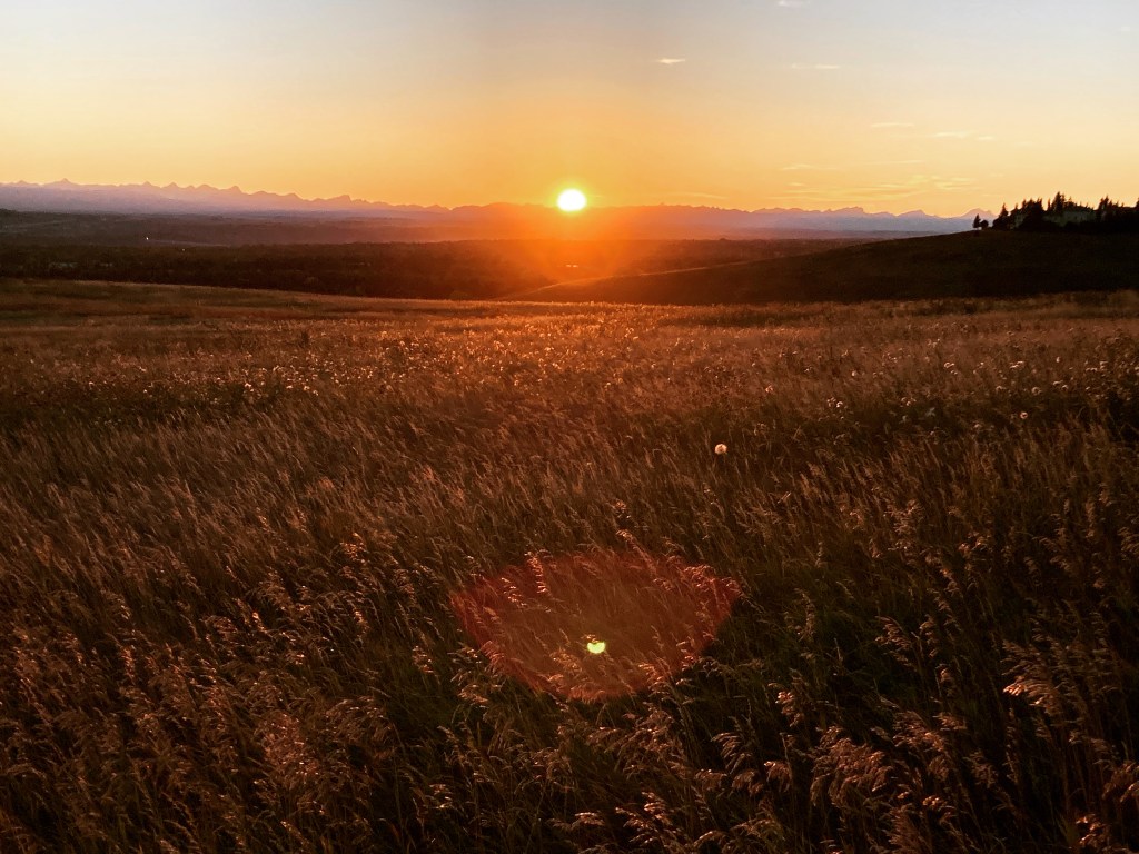
Thinking back to 2022, I hiked the Rideau Trail, spontaneously drove halfway across Canada to spend a summer in Calgary, and proceeded to follow the road wherever it could take me. I saw a lot. A lot happened.
When I think about the places I’ve been, every memory is coloured by my personal lens. Anyone can write about or share pictures of places. But those places mean different things to different people – that’s what makes them special, that’s why you may or may not want to read what I have to say. A place that sings to one person’s soul, might bore another. And sometimes our experiences of places are simply shaped by the luck of the draw – having a good or bad day, the weather, life. One thing I’ve learned passing through countless cities is that they all share a similar structure. They start to blend together after a while. But what sets them apart is the people, culture, history, landscape – and especially our personal connection to them.
This blog has always been an extension of myself. In part, it’s informational. It’s a documentation and something I (and maybe you) can reference for information, links, or just nostalgia. But I also see it as a form of storytelling. I want to share photos and information. But I also am going to share my interests, the connections I feel to places, and the thematic through lines that I was navigating that coloured my experiences.
Life doesn’t happen in a vacuum – there are layers and context. And I’m not one for shiny, superficial, influencer-style portrayals of perfection. These places have grit, and they get that grit from their history, and history can be messy. Our lives and our selves can be messy. There is a kind of perfection to imperfection, the uniqueness that only organic once in a lifetime moments and individual things can provide. As someone once said:
“good judgement comes from experience, and experience – well, that comes from poor judgement”.
The theme I’m starting with for this first blog back is ghosts. Three years out from being in Alberta, I know that this theme has deepened for me. I also just love anything Halloween-related and spooky. So it’s an on-brand place to start.
I’m bringing my blog up to date. Should anyone like to see a more visual presentation of these places you can check out my instagram, where I have already shared photos, captions, and reels.
Table of Contents
*This post is long and covers a lot – scroll for specific points of interest!
- Introduction / Moving Forward
- Table of Contents
- Calgary
- The Badlands
- Waterton
- Lethbridge
- Crowsnest Pass
- Canmore
- Icefields Parkway
- Jasper
- Banff
- Goodbye Alberta
- For Future Visits
- Important Information
- The End
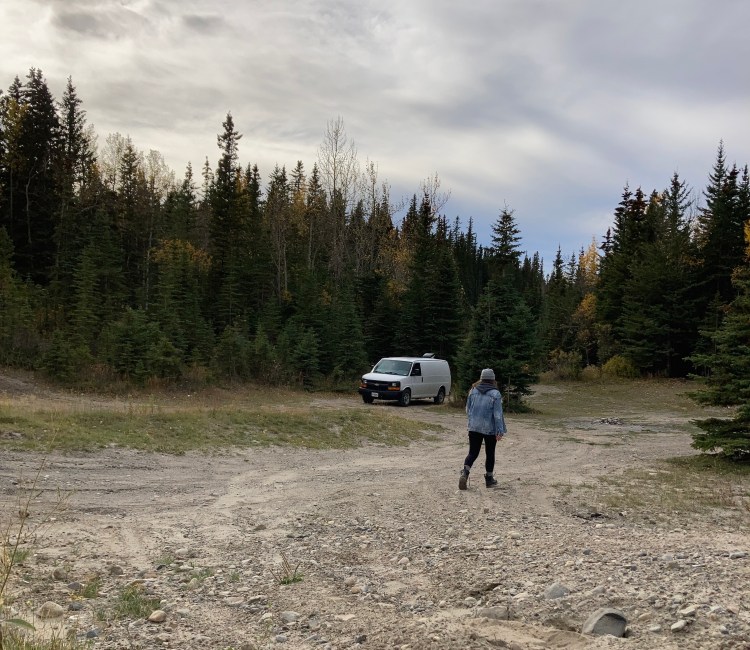
Calgary
During my time in Calgary I was fairly laidback on sight seeing. I was staying at my friends’ place, dog and house sitting for part of the summer. It took me a bit of time to adjust to being here – there was some culture shock, plus a total lifestyle overhaul. I spent some time researching – learning about Alberta, figuring out what I wanted to see (there’s a lot), and preparing for what the fall would bring. I didn’t have any set plans at the time, I just knew that I would hit the road again.
First Impressions

Welcome to Cow Town! Or Berta if you prefer.
My first impression of Calgary was that it was small. It does have a sprawling suburban area, but the city core is nothing like Toronto. It felt pretty chill to me.
Someone asked me what differences I noticed in Alberta, having come from Ontario. Other than the obvious (cowboys and mountains) I said the street lights. They hung horizontal, instead of the vertical I was used to. Striking. But it’s something you notice when you drive as much as I do.
I suppose also – all the grocery stores were different.
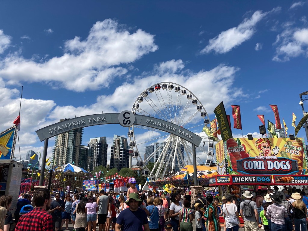
The Stampede
Having arrived in July, I was able to check out the Stampede. I was told about the free pancake breakfasts. Heading downtown for such a busy event gave me the opportunity to get to know the transit system (as Anthony Bourdain would say – be a traveller, not a tourist). I roamed the grounds and was glad to have the opportunity to take it all in. But in the future I would probably only go back for bands or the rodeo. Otherwise it was mostly like a crowded amusement park (no shade if that’s your speed!).
Nature
My friends’ place is on the edge of Fish Creek Provincial Park, so it wasn’t uncommon to get deer or even the occasional bear or lynx on local streets. The wild really overlapped with civilization. Neighbourhoods had facebook groups to alert each other to animal sightings or crime. And it was strange to me to be walking or running on paved paths in Fish Creek with signs warning of possible mountain lion presence. I had my head on a swivel as I walked my friends’ puppy in the park – small prey for a predator. Their pup was about 6 months old when I got there, but luckily he grew quickly (less likely to be picked off from some threat in the bushes).

♡
Elevation
The biggest adjustment to this prairie province for me, I think, was the elevation and dry air. I had come from southwestern Ontario, swamp country as I’ve come to call it, where you live on lakes (okay, it’s actually lake country, but it feels pretty swampy at times), humidity soars in the summer, and your elevation is just 75m above sea level. Calgary sits at 1,045m above sea level. So when I went for a run or a hike I felt like I couldn’t catch my breath. I’d never experienced that before. I was in decent shape at the time, too – fresh off the heels of a thru hike. The air was super dry and would grate at my throat. Dry air is great for being in a van (combatting condensation) and makes heat more bearable, but it definitely took some adjusting to.
It took about six weeks to feel like I’d acclimatized to the elevation on runs and hikes.
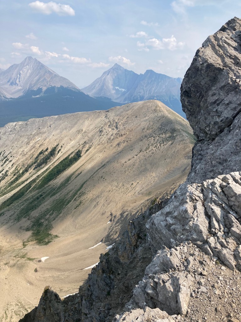
Hiking
Hiking here felt like a whole new ball game. I would consider myself a seasoned hiker – but my hiking has been done in the eastern Canadian provinces. And mountain hiking is very different. You’ve got dry sandy trails, switchbacks, scree, summitting ( and summit beers). Not to mention different wildlife – grizzlies, mountain lions, mountain goats. An endless number of mountains to explore. Vehicles suited to overlanding are recommended for getting to some of the more remote and beautiful hikes. All Trails was a great companion app. As well as the facebook groups Alberta Hiking Association and Hike Alberta.

Side note: one must visit a saloon when in Berta. My friends took me to the Powderhorn Saloon in Bragg Creek after we hiked Powderface in Kananaskis Country. You definitely get a dose of colourful culture here.

Hail
If you’re not worried about hail in mountain country… don’t let me hail on your parade! I always say, hope for the best, prepare for the worst. But my brain’s focus favours the latter, and I wish its worries on no one.
That said, it was not uncommon for me to see car bodies dimpled from hail or with cracked windshields. I was told stories of golf ball sized hail taking the siding off houses.
Luckily, I found an outdoor covered parking garage that I could actually get my van into (it had a higher than usual height restriction) at Southcentre Mall. If thunderstorms were in the forecast I would monitor the Weather Network’s radar maps for ice, and if hail was expected I would drive Strider to the mall to take cover. #ABStorm on “X” also had real time updates.
During this process I also learned that Southcentre mall had an RV reservations service for parking. At the time I didn’t need it. I was sleeping under a roof. And otherwise I was using freecampsites.net, not yet onto iOverlander (silly me). But it never hurts to add to your options.
Other advice on hail that I found (when I obviously researched the topic) included:
- Parking in your garage (duh).
- Parking to the side of a building (potentially helpful if hail is coming down at an angle).
- Getting a car cover
- A carport, inflatable car cover, or mobile car tent.
- Using a blanket.
- I had some people suggest cardboard or plywood placed over your vehicle. Or “strap an air mattress over him”.
- You could seek overhead protection at a gas station, under a bridge, or even under a tree if desperate (might slow the hail’s speed).
- A car’s speed could compound damage, or endure less damage, depending on your direction relative to the hail.
It’s a good idea to check if your car insurance would cover hail damage (it should with comprehensive coverage / all perils – mine covers falling or flying objects). But it might make sense to compare the cost of repair to your policy’s deductible as fixing a few minor dings might cost less. Take pictures (damage and weather) and keep receipts for repairs if damage occurs and you’re planning to file a claim.
Beer
One of my favourite things to do on the road is check out local craft breweries. I’m planning to write companion posts for destinations that go over the breweries I checked out and which were my favourite breweries and beers.
But here’s a list of beers and breweries I checked out:
- Craft Beer Market (more standardized, locations around Canada)
- Cold Garden (Birthday Cake beer!)
- Wild Rose (Alberta being Wild Rose Country)
- Prairie Dog
- Medicine Hat Brewing Company’s Creamsicle beer (hits a sweet spot)
- Greta Van Fleet specialty beer (they played in Calgary that summer)
- Tailgunner
- Annex
- The Establishment
- The Pass Beer Company (Crowsnest Pass)
- Grizzly Paw Brewing Co. in Canmore, overlooking the Three Sisters
- Jasper Brewing Co.
I mostly picked up cans from the local liquor store (Willow Park Wines & Spirits). But a friend let me in on the Collective Craft Beer Shop, which seems like the place to go for an on-the-pulse source of craft beer.
Downtown Calgary
It’s striking me now, that I might not have done Calgary a tourist’s justice. I know, I know – be a traveller, not a tourist. But I didn’t explore or immerse myself as much as I could have. When you’re living somewhere for an extended period, you really don’t have as much urgency to tour around. Every destination I hit on the road solo, when I knew I was just passing through, I always did research to learn what was available and worth seeing, and then tried to see as much as I could. I could see quite a bit in only a day or two. But having a couple of months in Calgary, and friends who lived there to advise on things worth seeing – I think I dropped the ball a little bit! I did a bit of research, sure, but I really didn’t treat it the same way as I did other places. It comes down to the whole “tourist in your hometown” thing. You can take a place a bit for granted when you think you’ve got time.
Or maybe I was just more focused on hiking and breweries…
Likely of little interest to you (but I’m a hiker nerd), was the presence of an MEC downtown. I’ll one-up my hiker nerd status by telling you that I also intentionally paid REI a visit, on multiple occasions, while in the states, as if it was a tourist destination.
I also found a cool little witchy shop downtown called Rite of Ritual (I told you I like spooky things).
I got to experience the Saddledome by attending a concert for The Pretty Reckless and Greta Van Fleet.
I discovered The Rose and Crown Pub on 17th Avenue, an old funeral home, now a pub, and said to be haunted. Although it has since closed.
I couldn’t tell you much about the nightlife, but I can say that bars scan your ID in Calgary and that’s the first time I’ve ever experienced that.
The Peace Bridge is a nice spot downtown and runs across the Bow River.
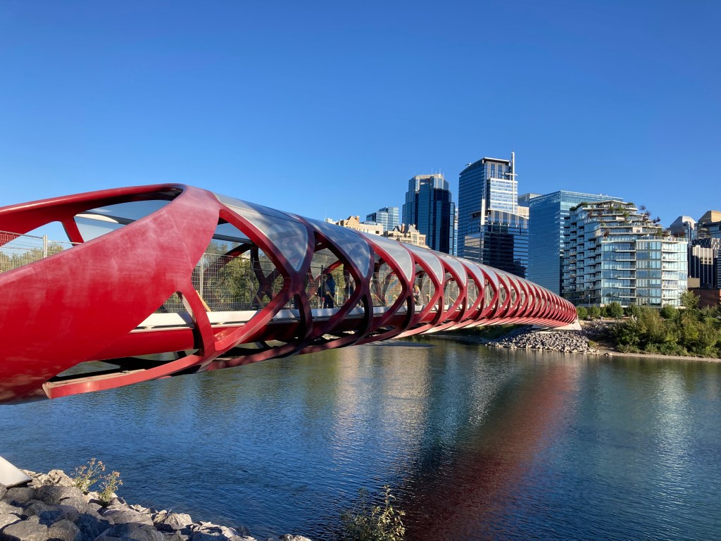
And speaking of the Bow River, the following summer I passed back through Calgary and got to paddle down the Bow River, something that seems to be a quintessential Calgary must do.
Other Locations
Nose Hill Park has grassland hikes in the city with views of the mountains and Bow River valley. I walked here at dusk and it was really pretty, especially being able to see the mountains.
I never got to Heritage Park (western living history museum) & Gasoline Alley Museum (old cars). But that was on my list.
Other Info
If by some obscure chance you are Calgary bound, still listen to the radio, and have similar music tastes to me – I clocked 97.7 as a 90s radio station and X92.9 has Black Hole Sundays (no, I don’t know what that means, but it’s a Soundgarden reference, so…).
Autumn is quite strange in Alberta when you’re used to having Maple trees around. Instead, people go crazy for the subalpine Larch, which turns bright yellow ’round about mid-September to early October. It’s a sight I’ve yet to zero in on.
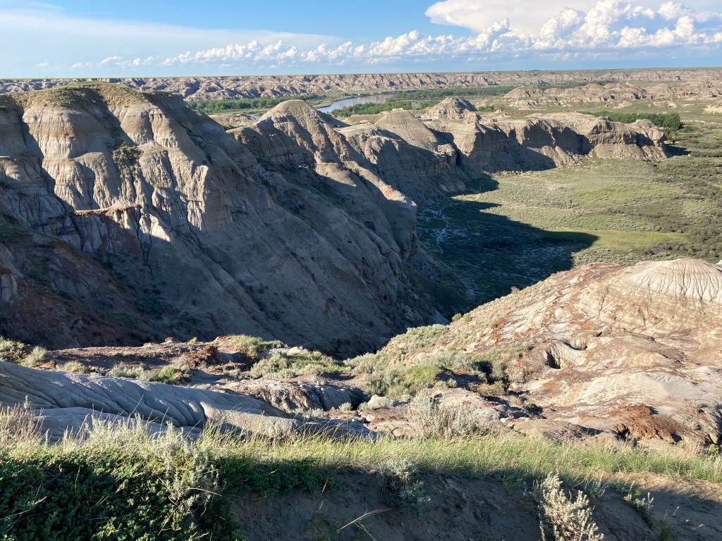
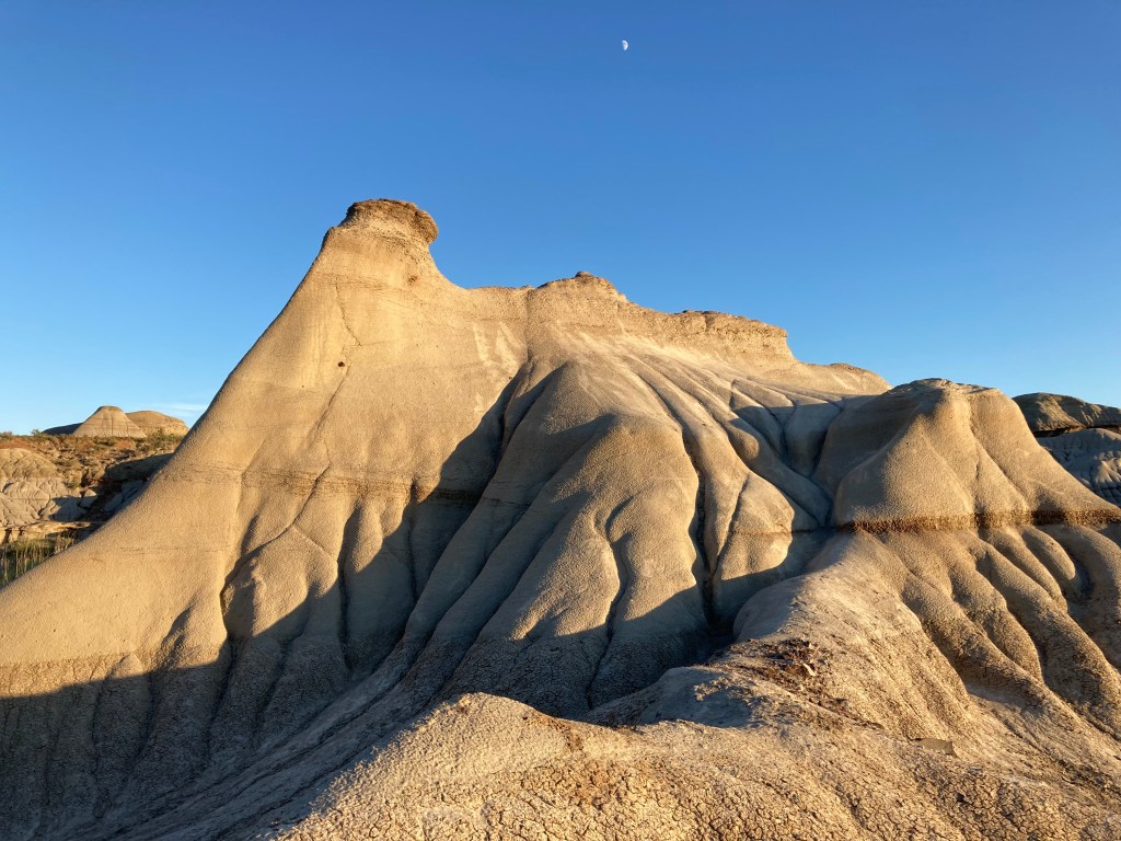
The Badlands
Come September, I knew my time in Calgary was waning. To ease back in to road life again, I did a little weekend trip back to the badlands. After all, Dinosaur PP had made a deep impression on me, and I didn’t want to leave Alberta without bidding it farewell. I also had been told about a haunted saloon near Drumheller, and with Halloween around the corner (who am I kidding, I’d check out a haunted place anytime of year) – I had to go!
Dinosaur Provincial Park
There is something about a desert that just really sings to my soul. (See more about this place in my previous post).
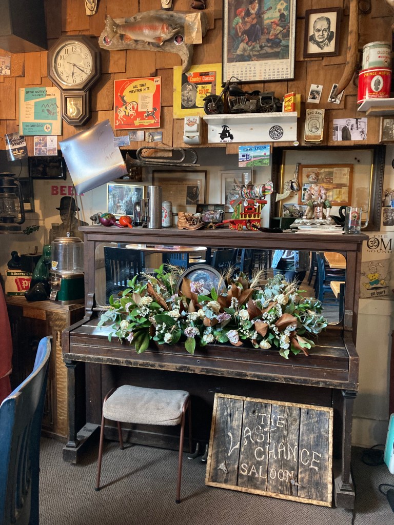
The Last Chance Saloon & Rosedeer Hotel
You might say that my chasing of ghosts in Alberta began with the Rosedeer Hotel.
The hotel and saloon can be found in an old mining town not far from Drumheller. There is rich history here, nestled in the badlands. It’s considered a ghost town, with only 28 people living in Wayne, AB now. Established in 1913, this building used to host miners, and now hosts bikers, musicians, and paranormal investigators. The area has 11 bridges. And in the 1920s the KKK burned crosses on the hills.


I happened to be the only guest in the hotel on the night I visited – and I was informed that no employees stay on the premises overnight, so I had the whole place to myself. I was told that they had a neighbour nearby who would be available should I need anything. They said they would tell him I was there. To be honest, I was a little nervous that a stranger knew I was there alone. And after the staff had gone, before the sun went down, I had wanted to take a photo of the building with the colourful skies behind it at dusk. So I went downstairs – and found the front door unlocked. That also made me nervous, to know that anyone could come in while I was sleeping. I know small towns are often thought of as safe – but I like to take precautions.
I might have been staying all alone in a place that had a reputation for being haunted – but it was the living and the unlocked door that scared me more.
But all in all, it was a great night. I can’t believe my luck, to have the place to myself. It was such a unique experience.
I highly recommend sitting down in their restaurant / saloon, too. They’ve got some good local beers (I enjoyed the Devils Row Coffee Lager – brewed in Drumheller with Alberta-grown craft malts), great food, and so many fascinating artifacts on the walls – including the bullet holes where an old bartender scared off some men trying to skip the bill.
And yes – I think the place is haunted.
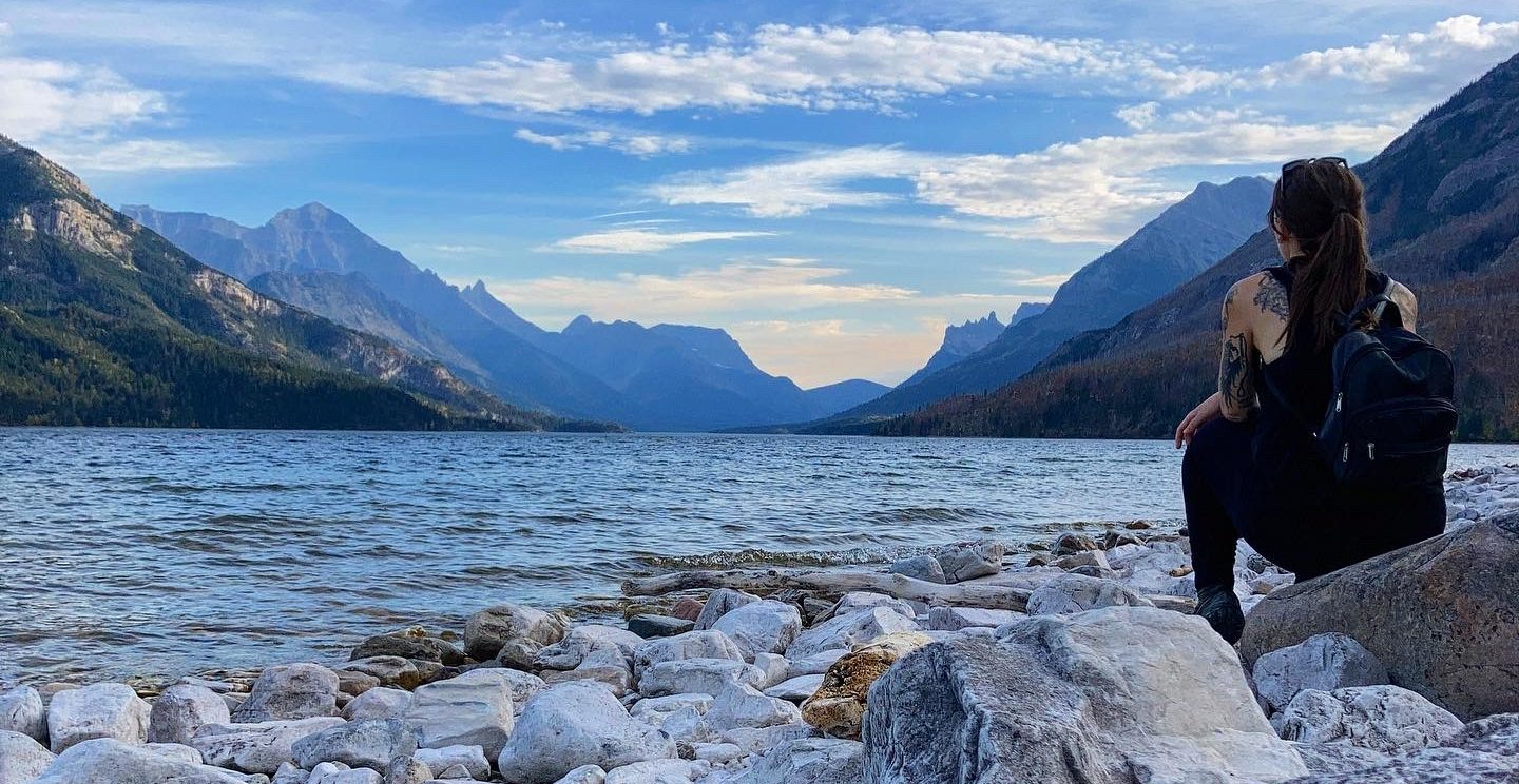
Waterton
Transitions
The weird thing about being on and off with vanlife is the transitions in and out of the van. There is always an adjustment period, at least for me. When I go into a house, the ease of everyday luxuries like a shower and laundry machine at my fingertips is not lost on me. It’s nice to not have to plan where to sleep every night. But I miss the road, I miss waking up at an earlier hour, or to see the sunrise – vanlife aligns me with the sun’s schedule. When I transition into the van, it’s exciting, but creature comforts evaporate, the unknown settles back in. And human beings often fear, or at least feel somewhat uncomfortable with, the unknown.
So the day I drove to Waterton I was a bit emotional. This might sound ludicrous to some people – I was going to visit amazing places after all. And you’re not wrong. But there were some of those layers of complexity. Shifts in social relations, abrupt change, and the following day was my Dad’s birthday. My Dad passed in 2014.
This is where we meet the next facet of chasing ghosts in Alberta.
GDT Ghosts & The Carthew-Alderson Trail
The year before my Dad died, he wrote a book. I had no idea he’d been writing, but when I found that book it was a priceless gift – his words and thoughts, something he could no longer share with me, that I had not yet seen. It was almost like trumping reality.
In that book, which was a work of fiction but felt like the main character was an extension of my Dad, a man and a woman set out to thru hike the Great Divide Trail (GDT). A trail that begins in Waterton.
The GDT is a dream trail for me to thru hike in Canada. Not only because my Dad wrote about it, but because it is an extension of the Continental Divide Trail (CDT), one of the triple crown trails in the US. This somehow makes it seem more legit, more high calibre. It runs along the continental divide, criss-crossing the Alberta-British Columbia border, through the Rockies for about 1,100km.
My Dad, to my knowledge, had not been to Waterton in his life. He had not been to many of the towns along the GDT. But his mind had. The fictional version of himself had. There was comfort in reading his words describe these places, then visiting those places myself. It did feel like chasing his ghost. It also felt like going to places that he never will, for him. As if he could see through my eyes and experience them through me.
So I left Calgary for Waterton Lakes National Park and on my Dad’s birthday I hiked the Carthew-Alderson Trail to Alderson Lake (13.4km, 701m elevation gain) – where the characters in the book spent their first night on trail. It was a stunning hike, starting from Cameron Falls and climbing along the side of a valley (in which I later saw a Grizzly running as I hiked back down) between mountain peaks. I had brought a beer with me and my “Dad’s cookies” – a special family recipe that he used to make all the time, that is essentially GORP in cookie form. I sat at the lake, with the mountains around me and not another soul around, and gave a cheers to my Dad. It truly felt like he was there with me, even if it was only the ghost of his characters, or his own.

I’ll always think of this song when I remember this hike.
I think doing this hike, and feeling closer to my Dad, comforted me and helped me through the emotions of transition. I think also the gruelling hike boosted my morale, as well as being on the road and braving the wildlife. You’ve got to push yourself out of your comfort zone in life – it shows you what you’re made of.
Over the next few days I headed to Lethbridge, AB and then Cranbrook, BC via Crowsnest Pass. But I came back to Waterton afterward on a mission to complete the infamous Crypt Lake hike.
Crypt Lake
The night before tackling this legendary hike I slept in the van at the Pincher Creek Walmart – which was actually an enjoyable Walmart with lots of space. Although it was here that I saw a truck with a license plate plastered with “Good Ol’ Boys” over a confederate flag. That sight was made up for by the sunrise I witnessed as I drove the 45 minutes into Waterton NP and the mountains glowing red.
As someone on the road, I am always hypervigilant of where I can find public washrooms. As I hadn’t stayed at a hotel or campground that night, it was very convenient to find that there were heated washrooms next to Cameron Falls that were open 24/7 – so I could put them to use early before embarking on the full day Crypt Lake hike.
You have to take a ferry across Upper Waterton Lake to the Crypt Lake trailhead at Crypt Landing – tickets are first come, first serve, and the ferry runs a tight schedule. So while I am not the kind of person who is ever early for things, I made damn sure I got here with time to spare.
Crypt Lake is a highly rated trail, rated one of the best in the world, with waterfalls, a cliff scale, and tunnel crawl. There seems to be conflicting information about its features though – Parks Canada says it is 17.2km with a 675m elevation gain, while All Trails says it is 18.5km with an 881m elevation gain. It is possible that All Trails is taking into account walking around the the perimeter of Crypt Lake (which not everyone does) and taking the Hell Roaring Falls side trail. Not sure why the elevation discrepancy.
I both walked around Crypt Lake and did Hell Roaring Falls side trail. My total hike time was 5hrs, and I spent about 1.5hrs additional just sitting at Crypt Lake and taking it all in, for a total trip of 6.5 hrs, giving me another hour or so wait time when I got back to the docks for the boat.
While sitting at the lake, it just felt like pure nature, unadulterated. And that’s the point – it’s quiet, that’s why people find peace here. It’s space and void and reset. It’s nature at its finest, and where humanity really realizes that vast importance of untouched nature and how and why we need to preserve the earth and limit our impact. It felt right.
On the way back down, near the end of the Hell Roaring Falls side trail, an animal growled at me. It was coming from some very dense and tall bushes that I had just passed, maybe 10-20ft away. I stopped and looked back, but I couldn’t see anything. It let out another low growl – it sounded big. Bear? Mountain lion? It was like a low growl from the throat, a warning. I consulted the Visitor Centre the next day and they said bears can growl, could also be a mountain lion, so I’m guessing one of the two. Maybe I would have been more scared if I had seen it. I just stood there for a few seconds, then slowly began moving away. I only had sound to go off, but it seemed like this animal did not want me around, and I was happy to oblige.
This was definitely an epic hike, and one I would do again in a heartbeat.


I decided to stay at the townsite campground for a couple of nights, which was cheap and close to everything. Waterton Village is small enough, and you can get around town and to trails with a short walk from this campground. Though be warned, in the shoulder seasons it is first come first serve, and if you pay for a site and then leave it during the day – you could come back to find someone who has self-registered has taken it (yup, that happened to me).
Bertha Falls/Lake Hike
The day after Crypt Lake I hiked to Bertha Falls and Bertha Lake (about 12km, 600m elevation gain). It’s a great open trail on the way up with lots of switchbacks and some great views. A bit overgrown once you get to the lake – if you attempt to hike around the lake, which is 4km around. The way the sun was shining (in the afternoon) it was hard to see the mountain wall at the back of the lake and views weren’t that much better closer up. Couple that with the overgrown trail, a bunch of bear scat, and seemingly no one else around – I wasn’t too keen on sticking around. I had made my way partially around the lake, but it was just not enjoyable, so I decided to turn back.
While there were no restrictions for hiking in groups, it was not lost on me that I was more exposed being alone here, and with the dense brush around the lake it felt more likely that I could come up on a bear without warning (I also hadn’t seen scat on the way up).

Beginning of the Bertha trail.
My night ritual at the end of a day in Waterton / a hike became walking from the campground to the bay and watching the sunset light on the mountains, with the moon on the horizon. It was autumn, I had a pumpkin beer, and just took it all in. My heart felt full, and maybe it was the endorphins from the hike, the beer, being freshly showered, feeling closer to my Dad… But it was wonderful.
There is over 200km of hiking in Waterton. I discovered a little too late about the Triple Crown of Waterton – which is now on my bucket list. I’d also like to tackle the Bear’s Hump hike, as one of the more popular hikes in the area.
Prince of Wales Hotel
I’d also like to go back and explore Prince of Wales Hotel. It was closed for the season when I was in Waterton, but they offer high tea from 12-4pm and even ghost stories (this was an offering daily at 8pm when I was in Waterton, but it may not be the same now). I did walk the grounds, and you get a nice view of the bay and mountains, with a walkway that points to the mountains, and gives their names and elevation.

Scenic Parkways
I of course walked through Waterton village and explored some stores. And on my way out of the park I drove a small portion of one of the scenic drives (I actually can’t remember if it was Red Rock Parkway or Akamina Parkway).
Lethbridge
This was a random and impromptu detour that came about only because a band I loved was passing through AB, and while I already had tickets to see them in Calgary, I knew I wanted to stay longer in Waterton and didn’t want to drive the 2.5hrs to go back to Calgary, so instead I bought tickets to a closer destination – Lethbridge. Bonus: I’d never been, and I do love to explore new territory.
What band was worth the trouble, you might ask? None other than Canada’s The Pack A.D., hailing from BC. I discovered them when I was in university, and if you don’t know them, I highly recommend them as one of Canada’s best.
I didn’t invest a lot of time researching and exploring Lethbridge. I made mental notes of the Oldman River Observatory and Fort Whoop-Up (an old trading post that hosted an illegal whisky trade in the 1800s). Lethbridge seems to have a small downtown, low buildings, an artsy area near Galt Gardens park. The Lethbridge Viaduct is a big bridge by the highway, apparently with trails accessible at Indian Battle Park (but my phone’s maps took me to places that were not straightforward to access, so I just looked from afar). It was kind of a miserable rainy day, so I didn’t stay long and drove back to Pincher Creek Walmart (just an hour away) to sleep for the night before exploring Crowsnest Pass.

Crowsnest Pass
Crowsnest Pass is an area in southwestern Alberta that runs along Highway 3, west of Highway 22, towards the BC border. It is characterized by its location among the Rocky Mountains and its rich coal mining history. You can take this scenic drive, find various hiking trails, and take in the history of the amalgamated communities of Crowsnest Pass (Hillcrest, Bellevue, Frank, Blairmore, Coleman).
The Burmis Tree
Travelling from east to west one of the first landmarks you’ll come across is the Burmis Tree. The Burmis Tree is a limber pine that is estimated to be about 700 years old. It is considered a symbol of endurance for the people of the Pass, able to grow and prosper in harsh conditions. While this tree died in the 1970s, and toppled in 1998, the community raised and secured the tree so it could remain standing on its sandstone pedestal, greeting and welcoming visitors and residents to Crowsnest Pass. It is found just off the highway in Burmis.

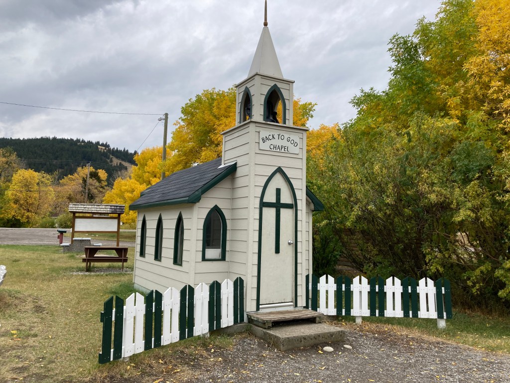
Bellevue
There is a mini church, reminiscent of the one in Drumheller, called the Back to God Chapel (or Wayside Chapel on maps).
Bellevue also has an Underground Mine Tour.
Frank Slide
The town of Frank is known for Frank Slide, Canada’s deadliest rockslide, which occurred in 1903 and killed 70-90 people (out of the town’s population of 600). The landslide came from Turtle Mountain. You can stop along the side of the highway here, where you will find an informational sign. You can also visit the Interpretive Centre and Frank Slide Trail, which takes you through the rubble.
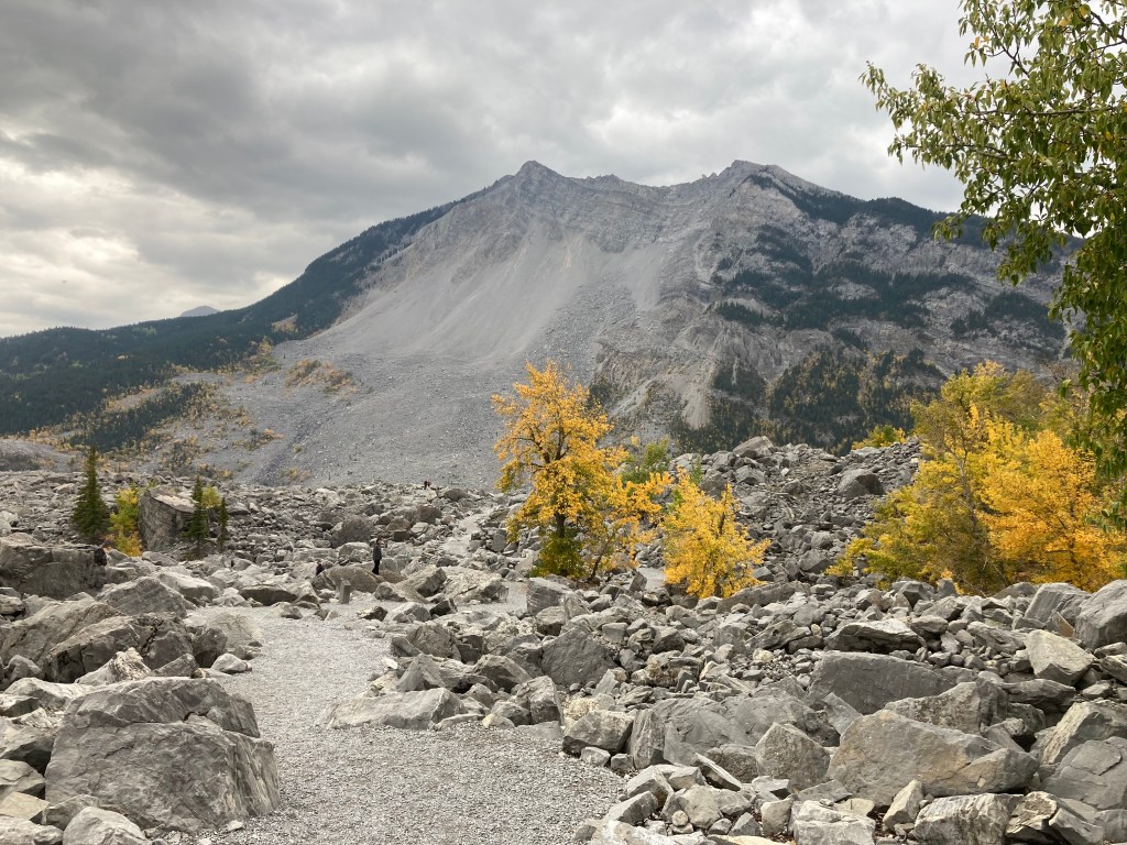
Many remain buried in the rubble, but some were found and moved to Frank Slide Memorial Cemetery.
Near Frank you can also hike the Lille Ghost Town Trail if eerie areas are up your alley.
Blairmore
Blairmore used to be a lumber and coal mining town, and is now the primary commercial hub of Crowsnest Pass. This is where you will find The Pass Beer Co., a perfect spot to take a break on your travels.
I of course got a flight, and since it was October I had the pleasure of sampling some seasonal delights, including a coffee vanilla cream ale and a rye festbier.

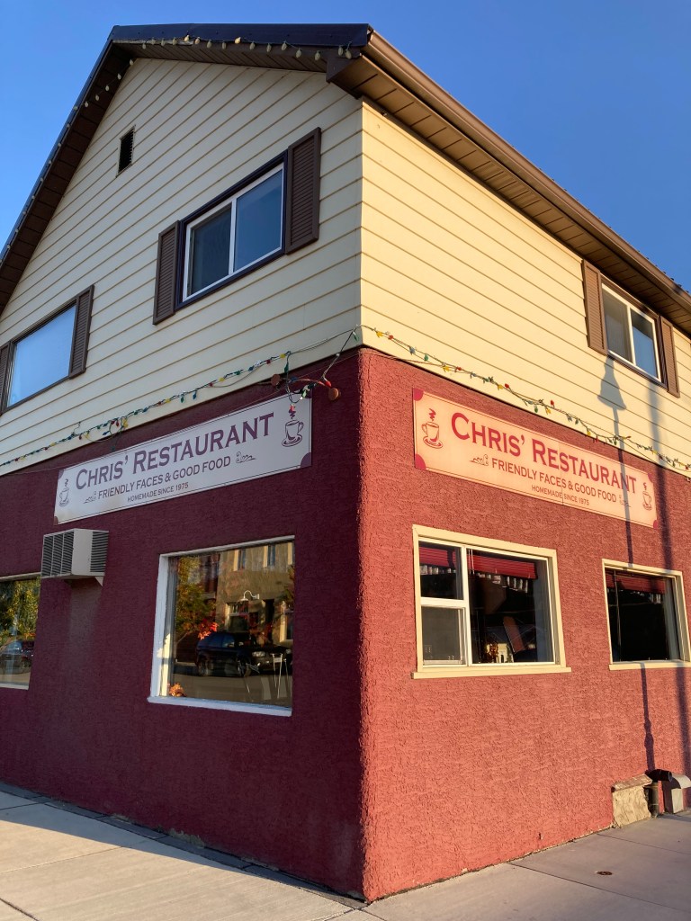
Coleman
While Frank was sombre and reflective, and Blairmore offered a convergence of convenient amenities, I found Coleman to house a unique charm. There was just something charming about the Miners’ Path hike – a leisurely trail through the woods where miners used to walk to the mines – and the quaint downtown area. There were historical buildings and art on brick walls that exhibited character. There were old model cars in the streets. And it lies on the Canadian Pacific Railway. Coleman is a National Historic Site, and the GDT passes through it.
It was also a town that my Dad wrote about. The characters in his book stayed at A Safe Haven B&B – a real place, as it turns out. They sat down to a meal at Chris’ Restaurant – a “working man’s restaurant” (I would have, too, had it been open when I was passing through). Perhaps there is nothing like word of mouth to warm you up to a place. Or the nostalgia and familiarity that counter-intuitively come from the storytelling of a dear loved one.
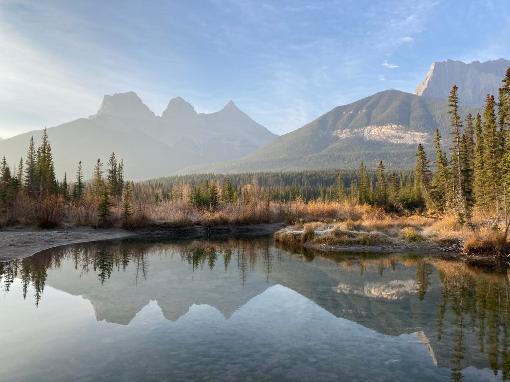
Canmore
Canmore is one of Alberta’s best mountainside tourist towns, and you’ll know it by its iconic landmark – the Three Sisters mountains.
Personally, I’d take Canmore over Banff any day. I find myself to be less inclined towards tourist hot spots. I’m also the kind of person who would much prefer going somewhere in an off- or shoulder-season. Unfortunately, if you are wanting to tackle certain hikes in the mountains you do only have a specific seasonal window. So I will brave the popular seasons to get the experiences I want. And these towns offer more than their core downtown areas and most popular hikes.
Canmore has a lovely downtown area with many shops to explore. There are trails around town along rivers (Bow River Loop) and through fields (Policeman’s Creek Boardwalk), giving views of the Three Sisters and the log cabin style homes. You might even see elk like I did.
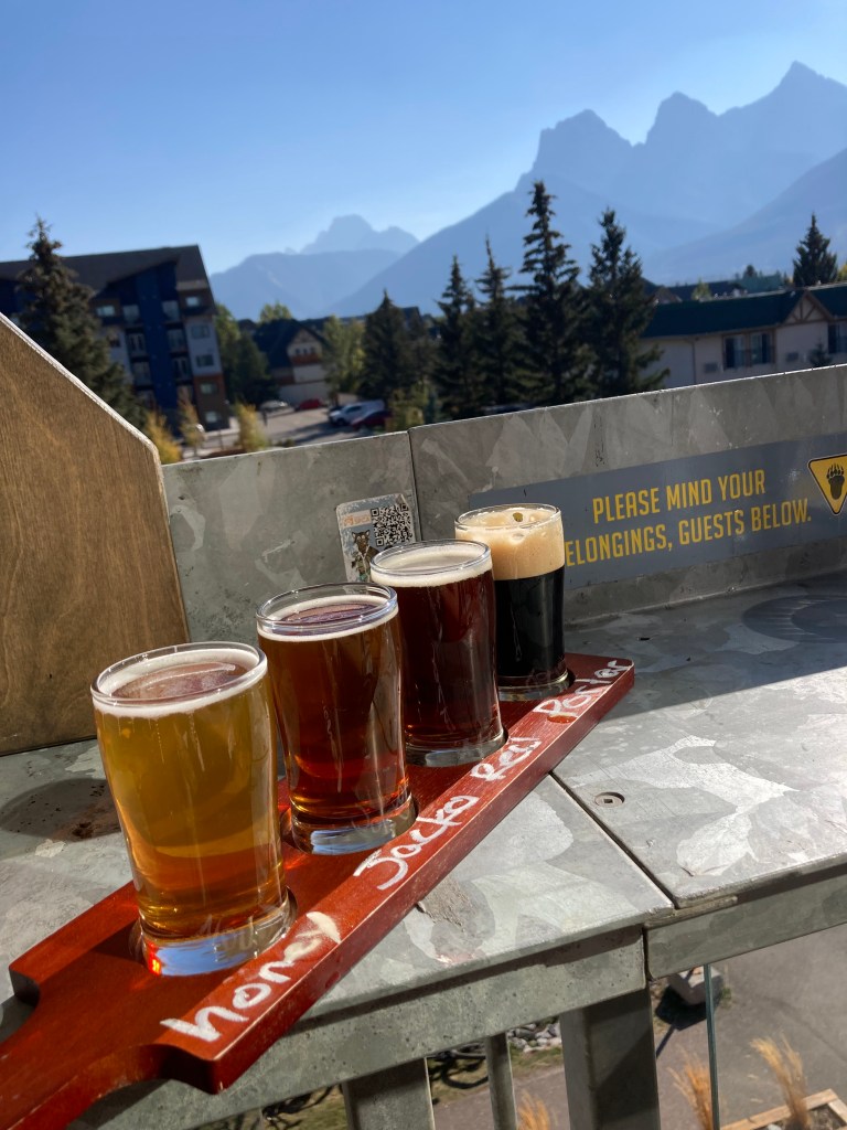
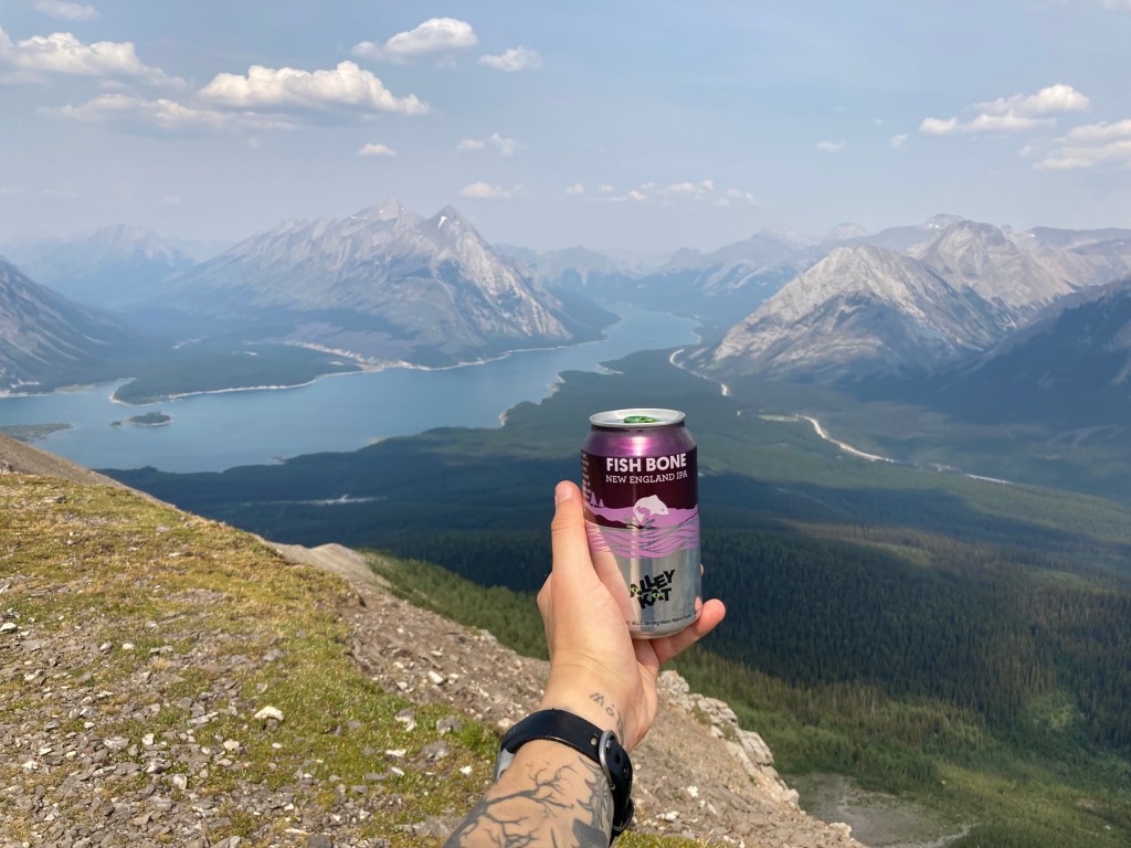
One of the first things I did in Canmore was stop in to the Grizzly Paw taproom (not to be confused with the pub and restaurant location) – not just because I love breweries – but I needed to plan out some of my travels. Breweries are a great place to multitask. I got to sit on the balcony with a view of the Three Sisters as I sipped on a flight and looked up things to do (I planned my travels very much on the fly).
While you cannot park overnight in Canmore (last I checked), there is free daytime parking downtown behind Home Hardware. So I headed here after Grizzly Paw to check out the downtown area – Main Street / 8th street. It was fun to explore the shops and pick up a few souvenirs. I then walked along local trails to take everything in.
Since you can’t park overnight in Canmore or in the Parks, I stayed overnight in the Stoney Nakoda Casino lot. You just register with the front desk, and I found several other vanlifers and RVers doing the same. Wild horses would come through the parking lot. And I had no issues. At the time I was not yet using the iOverlander app, so if I was back in the area I might find a different spot to overnight.
It’s good to keep in mind in this area whether you need some sort of pass – you don’t need a pass in the municipality of Canmore, but you would if you were hiking and parking at, say, Ha Ling Peak or Grassi Lakes (day pass or Kananaskis Conservation Pass). On that note, you do need a pass in the town of Banff (day pass or Parks Canada Discovery Pass). I would also recommend checking trail advisories.
Looking back, my time in Canmore was brief. I would love to spend more time there. And I did get to pass through again the following year to tackle the Ha Ling Peak hike with a friend!

I am sure there is no shortage of hikes to do in the future. And I will say – I am not a winter sport type of person (I know, I know, this is where mountain areas shine) – but if you’re into cross-country skiing, check out the Nordic Centre.
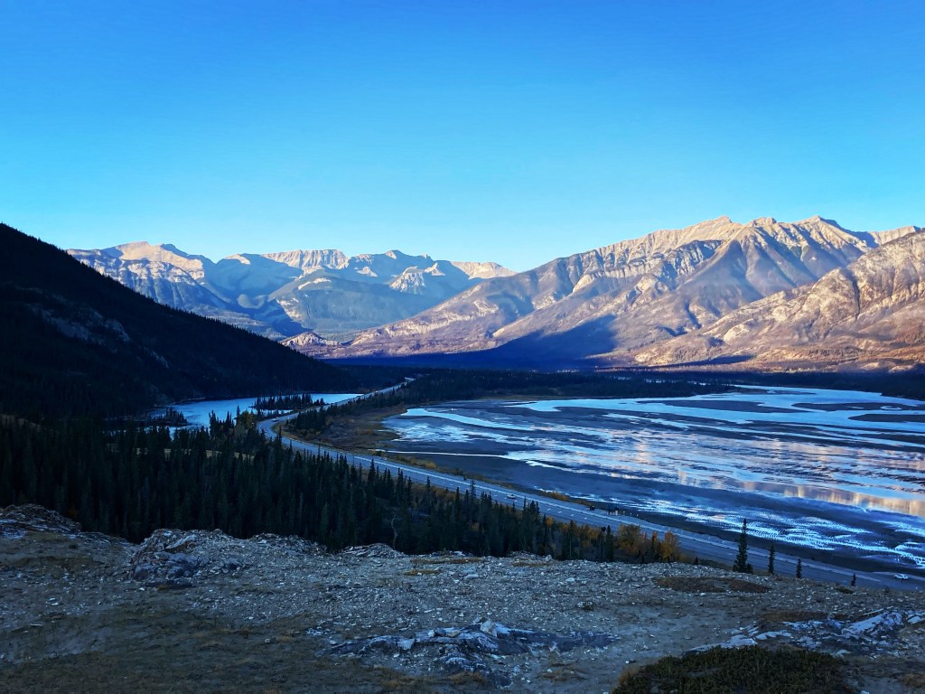
Icefields Parkway
Banff would be your next logical destination following Canmore. But for reasons I can no longer remember, I decided to bypass Banff (for now) and head to Jasper. This meant exploring two beautiful parkways on my way there.
First, the Bow Valley Parkway, Highway 1A, which essentially is a smaller road that runs parallel to the TCH from Banff to Lake Louise, just south of where highway 93/ the Icefields Parkway begins. The Bow Valley Parkway offers some scenic views, like Morant’s Curve viewpoint, Castle Mountain lookout and trail (I quite enjoyed simply looking at Castle Mountain), and Johnston Canyon (an easy hike along the edge of a canyon to waterfalls and caves). Be prepared for slower driving and a winding road. I would only drive the Bow Valley Parkway again if I had a destination along it in mind, otherwise the TCH (highway 1) is faster and still offers beautiful mountain views.


Next up, I took the Icefields Parkway (Highway 93 North) from Lake Louise in Banff NP, to Jasper/ Jasper NP. This drive was absolutely stunning, taking you up close and personal with the Rockies. There are more than one hundred glaciers along this road.
I pulled over at various turnouts on a whim to take in the views. But one of the places I intentionally stopped at was Peyto Lake, the famous fox-shaped, turquoise blue, mountain lake that will dazzle you.
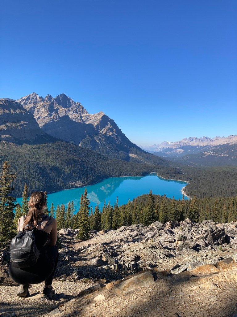
Getting to Peyto Lake from the parking lot is a short uphill walk along a paved trail. There is a viewing platform here, but it was extremely crowded. So I decided to keep walking. I ended up hiking on the Bow Summit trail, which had additional beautiful views and less tourists. On the way back I found a side trail and took it down to water level of Peyto Lake. It was a decently steep incline and gave me a workout on the way back up. But then I came across an alternative view point of Peyto Lake – with zero people around – and I got to take some photos and enjoy the view all to myself.
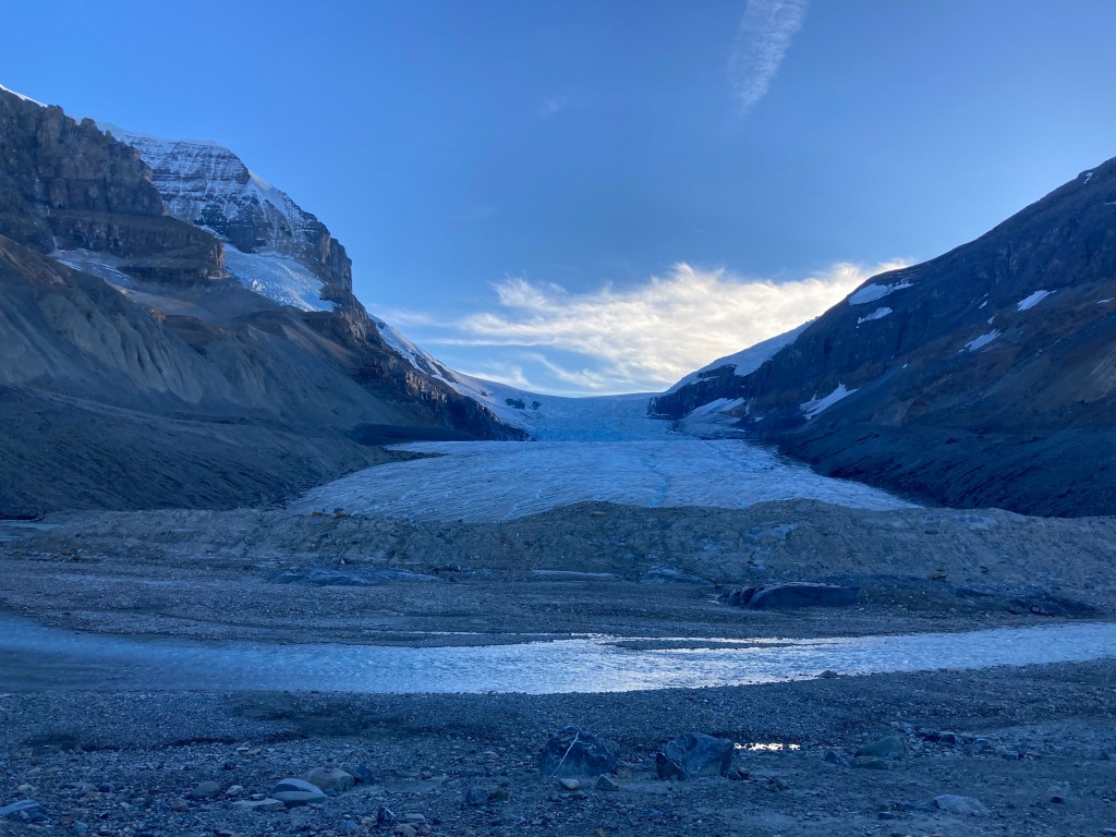
The second major stop I made along the Icefields Parkway was Athabasca Glacier, part of the Columbia Icefield – the largest icefield in the Canadian Rockies. There is parking off highway 93, and you can hike about a kilometre to the “toe” of the glacier. For a more in depth experience there are also tours that drive you up onto the glacier, and you can walk along the Columbia Icefield Skywalk – a structure with a glass floor that hangs off the edge of a cliff.
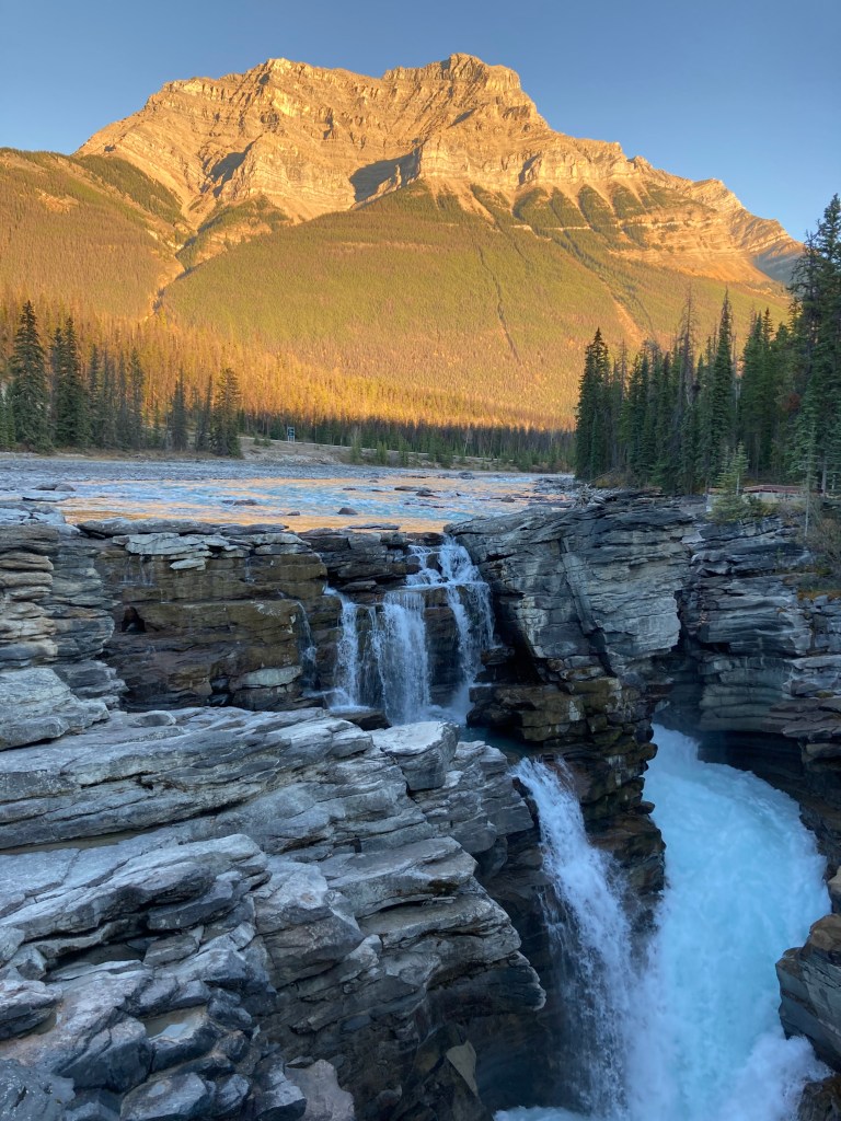
I made a few more stops along the Icefields Parkway following a week spent in Jasper. I earnestly took it in, not knowing if or when I might get back here. I stopped at Athabasca Falls and Sunwapta Falls

I was pressed for time as I started the trek back from Jasper to Banff. As is not uncommon for me – I was racing sundown – seeing as much as I can tends to take priority over getting to an overnight spot at a reasonable hour. So as it was getting increasingly dark I finally surrendered to the fact that I wasn’t going to make it to my intended overnight spot. I both was not comfortable driving mountain roads after dark (winding, wildlife, getting tired) and actually wanted to see the views, so I started looking for alternative overnight options.
I’m someone who likes to have a plan for where I’m going to park for the night – but vanlife teaches you (or forces you) to be flexible and figure things out on the fly. Ideally, I wanted to look up overnight spots to plug into my phone maps for navigation. But it probably wouldn’t have mattered if I’d found a turnout to pull over in because much of the Icefields Parkway doesn’t have cell service. So I had to figure things out the old fashioned way. That meant keeping my eyes peeled.
You can’t legally park overnight in turnouts. Fortunately, my headlights caught some cars ahead in what seemed to be a small parking lot. I pulled over to find that it was a hostel. I asked someone if I could park there and lucked out, catching some shut eye until the sun came up.
While this was a bit of a stressful experience in the moment, it’s also the kind of experience that shows you that you can hack it on the road and that you can be resourceful when you need to be.
There are definitely more spots for me to explore on the Icefields Parkway, like the Weeping Wall and checking out the ice bubbles in Abraham Lake during winter (despite me not relishing driving through the mountains in the winter months). And I do hope I can get back there – it’s just an amazing drive.
Jasper
Jasper has a special place in my heart. But it’s hard to say it’s my favourite (in Alberta), because I feel that Waterton and the Badlands also speak to me.
As I completed my trek along the Icefields Parkway, witnessing a family of black bears to the side of the road, I arrived at Whistlers Campground, which is just outside of Jasper. It was October at this point and I just nabbed a site before the campground closed for the season (as I came to find a lot of things closed for the season in the mountains in October – like access to certain trailheads and Moraine Lake). I really enjoyed this campground. I’ve seen my fair share of campgrounds after being on the road full time – from private campgrounds to provincial / state campgrounds – and I can say that this was one of my favourites. It was clean, well organized, spacious, and the comfort stations were top tier. It probably didn’t hurt that there weren’t that many people around, it being the end of the season.
The next day I explored downtown Jasper. I went to some shops, the visitor centre (which had one of the best gift shops in town I thought), the old railway station and train, and of course Jasper Brewing Company for a flight.
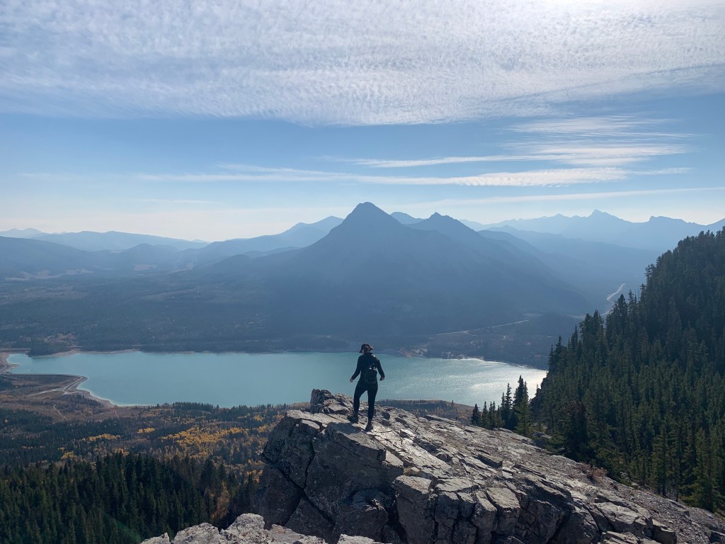
As Jasper is in Jasper National Park, you do need a pass to park anywhere, and overnight parking is prohibited. The campgrounds were closing, but I also don’t fancy paying for accommodations every night when on the road full time. The closest crown land spot I found was about 50km north of downtown Jasper at a spot called Brulé Lake. And to be honest, while it was a bit of a slog to get to and from each day, it was also worth it because I had quiet nights and got to take in the mountains repeatedly – and how could you get sick of those views!? I saw elk along the way, and witnessed smoke from wildfires (not too close to Jasper or my overnight spot).
I found a few random spots off the highway north of Jasper where I stopped to explore. One was a little hike that gave great views of the surrounding area:

I also visited the Fairmont Jasper Park Lodge. Now you might think that visiting hotels is an odd thing to do – but they can be in beautiful locations, have rich history, and exhibit stunning architecture. Like Banff Springs Hotel, which is one of Canada’s grand railway hotels and said to be haunted, or Hotel del Coronado in San Diego which has Top Gun merch and photos of celebrities and presidents on the walls. These types of hotels also often have shops on the bottom level – I picked up a fuzzy sweater at the gift shop here in Jasper.
But one of the main reasons I wanted to check out the Fairmont Jasper Park Lodge was because my Dad had written about it. The GDT runs right by it, so naturally the characters in my Dad’s book stayed here. My dad was both frugal and smart with money, as well as someone with good taste who would splurge on quality, on special occasions, with only the best. I took in the places where the ghosts of my Dad’s imagination might have roamed. And I took a stroll along a portion of the GDT next to the hotel.
While the trail to Edith Cavell meadows (7.4km, 555m elevation), which I really wanted to do, was closed for the season, I did another popular hike instead: Maligne Canyon (3.7km loop, 128m elevation gain). It was an easy hike, a bit crowded for my liking, but had views of the mountains, took you along mountain rivers with turquoise waters, and through the canyon with waterfalls.


Finally, I visited Pyramid Lake boardwalk and Island, which is a little area to walk around at the “base” (up close) of Pyramid Mountain, which was one of my favourite peaks around Jasper. Pyramid Mountain gets its pink and orange hues from the weathered iron pyrite or “fool’s gold” in the rock, along with quartz.

While Jasper was beautiful in mid-October, the unfortunate part was that some of the best areas were closed for the season. In addition to hiking at Mount Edith Cavell, I would have loved to see Spirit Island on Maligne Lake. This iconic island is only accessible by boat. You can paddle yourself, which is said to take around eight hours roundtrip, or take the Maligne Lake Cruise (closes for the season October 12th).
There were of course things that I just didn’t get to. I’ve heard the Bald Hills hike is a great one. There’s also the Jasper SkyTram, which offers aerial views of the national park, taking you to the summit of Whistlers Mountain.
Finally, the forest fires in Jasper during the summer of 2024 left a lot of destruction and the town and park are still dealing with the after effects – something to keep in mind for future visits.
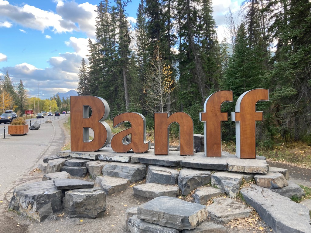
Banff
Banff – Canada’s first national park. Nestled among the Canadian Rockies, about 130km west of Calgary, just west of Canmore.
After travelling beyond Alberta the following year, and having driven through Oregon and along the Cascade mountain range, I can now say that the Canadian Rockies are in a class of their own – at least compared to the Cascades. The Cascade Mountains are one-off peaks, spaced out from each other. They’re beautiful in their own right, but the rockies are a range – you’re surrounded by peak after peak.
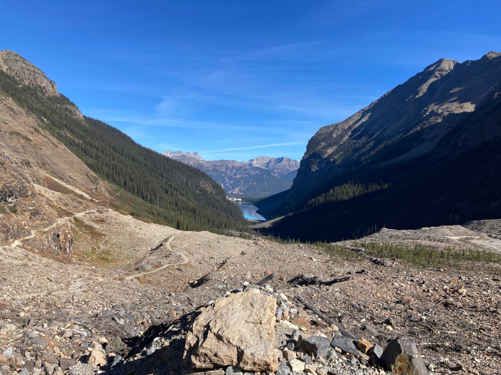
Lake Louise
The first thing I did within Banff NP after returning from Jasper was go to Lake Louise. It wasn’t my first time here, but it was my first opportunity to hike around the lake. And I didn’t skimp. I took in the well known (and crowded) foreshore view, then what started out as a short walk around the edge of the lake quickly turned into a hike up Plain of Six Glaciers, followed by Big Beehive and Lake Agnes/Tea House. Since I’d only planned on a leisurely stroll, I hadn’t brought water with me… always bring water. You never know how plans might change, whether of your choosing or not. I ended up hiking for 5.5hrs! Other than the dehydration, it was glorious. And that’s me for you – I might not commit, but once I’m there I’m likely to push my limits.
I heard one person during my hike say that they never wanted to see mountains again – I had to chuckle (incredulously).

Lake Louise is one of the top attractions in the area, and as such snagging a parking spot requires arriving early. As a night owl, that is akin to the bane of my existence. But with the right motivation I make it happen. As it was getting late in the season, I believe I arrived a little before 10am and there were spots to spare. Though I would say within a half hour of that they were all full. In the summer it is advised that spots can be gone by 8am on weekends and 9am on weekdays (some even say by sunrise).
I would be remiss if I did not mention Moraine Lake here – but sadly by the time I looked into visiting – it was closed for the season. Known for its turquoise waters, in the Valley of the Ten Peaks, Moraine Lake rivals Lake Louise for most popular Banff destination. I think I’ll be adding the Paradise Valley hike (19.5km, 1,134m elevation gain) from Lake Louise to Moraine Lake to my bucket list! And based on this article, probably Eiffel Lake Trail (11.9km, 591m elevation gain) – which extends to Wenkchemna Pass (17.7km, 919m elevation gain), *Sentinel Pass (11.1km, 798m elevation gain) – via *Larch Valley (8.9km, 564m elevation gain, ideally late September), possibly Tower of Babel (2.7km, 496m elevation gain, scramble, helmet recommended), and maybe work up to Eiffel Peak (10.6km, 1,265m elevation gain, difficult) or Mount Temple (15.4km, 1,703m elevation gain, extends from the Sentinel Pass trail).
When I had been in Alberta there had been hiking restrictions in place for some of the trails around Moraine Lake, requiring that you hike in groups of at least four due to bear activity. As I write this it looks like those restrictions are not in place currently – so it’s good to keep on top of various closures and restrictions. But Moraine Lake is closed during the winter (other than cross-country skiing to a lookout), and you can only access it via shuttle and reservation in the summer.
Banff Townsite
Sulphur Mountain Hike & The Banff Gondola
There are obviously a lot of hikes to choose from in the Banff area, but the one I tackled was Sulphur Mountain (about 30 switchbacks, 11km, 756m elevation gain). You can take the Banff gondola to the top – and I had some kids yell out to me from that in a semi-mocking tone, as if they had somehow won by being carried to the summit. But I had the last laugh in my books because I got a workout, earned my way to the top, and didn’t spend a dime to get there (they paid about $70 – the price has increased since then). It took me about 1hr20mins on the way up and one hour on the way down, and I spent about 40 minutes exploring the observation decks, views, and gift shop up top. It was quite frigid on the summit, with a strong wind, but a comfortable hike on the switchbacks.
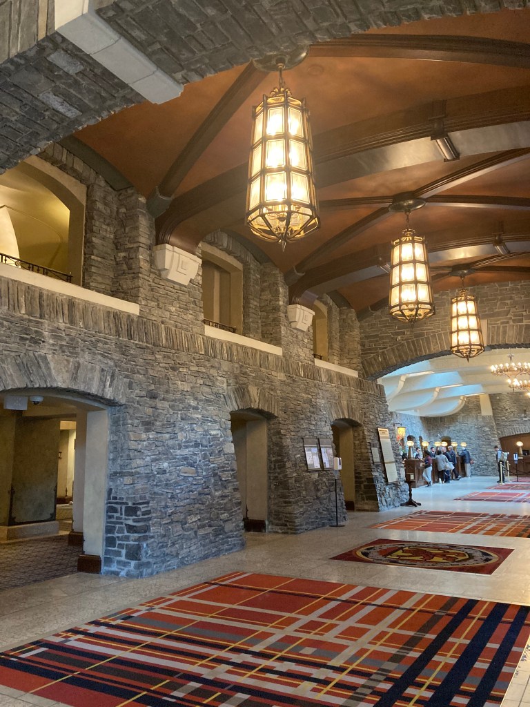
Banff Springs Hotel
Following my hike I headed over to the Fairmont Banff Springs Hotel, Canada’s “castle in the Rockies” (and I am always down for a castle). The draw was the architecture, the history, the luxury, and the hauntings. The hotel was opened in 1888 by the Canadian Pacific Railway and was one of the first of Canada’s grand railway hotels.
Side note: Canada’s grand railway hotels are described as local and national landmarks that represent Canadian history and architecture. Each was originally built by Canada’s railway companies and served passengers on Canada’s expanding railway network, promoting travel in style. Architecture was commonly in the Château style. Some hotels of this style include the Royal York in Toronto, Château Frontenac in Québec City, Windsor Hotel in Montreal, The Empress in Victoria, Château Lake Louise, and Château Laurier in Ottawa.
Since I was here in October, the ghost stories were even more appropriate, as gloomy skies hovered overhead and golden leaves blew around me on chilled winds that day. I walked through the lobby of Fairmont Banff Springs where you can see the staircase – it is said that there resides a doomed bride in the cascade ballroom, who caught fire on an open torch and fell down the stairs to her death. I walked past the elevators – where Sam the Scottish bellman is said to open and close the elevator doors still, helping people, or extending a silent hello. My Dad wrote about this hotel, calling it the Canadian version of the hotel from the Shining.

I then walked down to the Bow River and took a look at Bow Falls.

If I were to return to this area I would definitely check out Surprise Corner viewpoint for the iconic view of Banff Springs Hotel over Bow River and against the mountain backdrop.
Downtown Banff
I truly just walked up and down Banff Avenue and explored to my heart’s content. I parked near the train station, walked over to Mount Norquay Road to take some photos alongside the Banff sign (apparently the sign is going to be moved in the near future). Then walked to Banff Avenue. Sometimes the best way to travel is to just explore with no set destination and no pressure, just doing what calls to you.

That said – I missed checking out Banff Ave Brewing Co. (but I did pick up some cans from store where I found a “Cake It Till You Make It” ale from Longslice Brewery, and let me tell you – it was scrumptious).
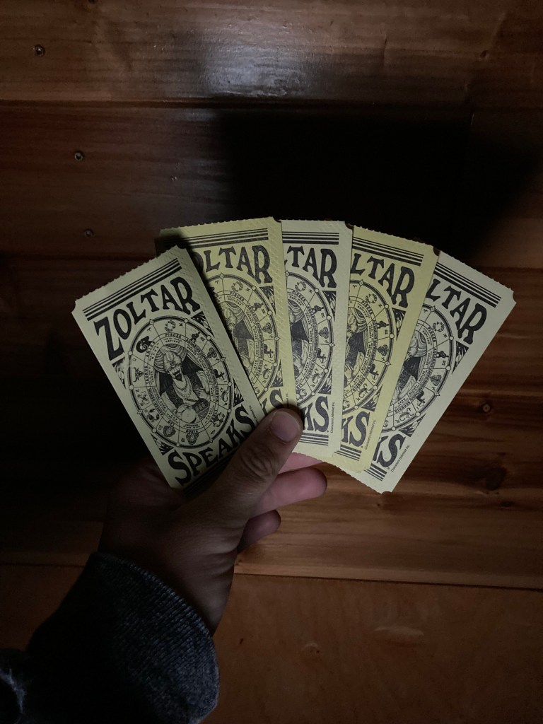
There were informational plaques, Cascade and Rundle Mountains looming above, beautiful storefronts. And here began a tradition that would continue on the road with me – getting my Zoltar fortune. There is a Zoltar on Banff Ave., and many of them along the west coast, and somewhere along the way I decided that if I were to come across a Zoltar I had to get my fortune.

Tunnel Mountain
While I didn’t hike Tunnel Mountain (it’s on my list of hikes to tackle in the future), I did stay at Tunnel Mountain Village 2 Campground, which is open year-round! I enjoyed this campground. It was pretty open-concept, and I imagine the fact that there were very few people around contributed to my impression. But it’s nice to know that there are campgrounds open in the mountains all year.
The next morning was beautiful as I drove to my next destination and saw just how close the clouds can feel in the mountains.

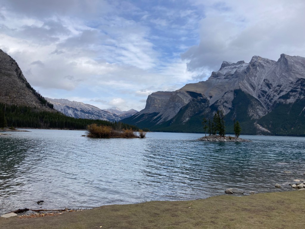
Lake Minnewanka
Lake Minnewanka is the biggest lake in Banff NP at 21km long. The Stoney Nakoda First Nations people called it Lake Minn-waki or Lake of the Spirits, and had both respect and fear for the resident spirits here. There is an underwater ghost town at Lake Minnewanka, and you’ll see scuba divers checking out this submerged resort town, which was covered by water in 1941 after a dam gave way. The lake’s shores are also archaeological sites where artifacts up to 14,000 years old have been found.
One of the most popular activities here is taking a cruise on the lake where you can take in the sights and learn about the area. Add to my list of things to do: the Lake Minnewanka Beer Voyage Cruise!
Hiking is also of course a great option, whether it’s strolling along the lake’s shore, or taking the Lakeside Trail (16.3km, 544m elevation gain), Stewart Canyon (6km, 236m elevation gain) trail, or Aylmer Lookout (23.2km, 1,040m elevation gain) trail. Of note – beyond the bridge at the mouth of the canyon restrictions seem to come into effect where hikers must be in groups of at least four and carry bear spray. There is also C Level Cirque (9.8km, 781m elevation gain) which takes you along the side of Cascade Mountain and gives views of Lake Minnewanka at the top.
Goodbye Alberta
After spending time in the Rockies, I started to become enamoured of learning the names of the mountains. There was something about it that was like making friends, or perhaps the familiarity felt like building a kinship with the area. It gave the place character and helped me to learn about the area and get my bearings.
As I set out to leave Banff and Alberta, dusk approached. In retrospect, I should have just waited until the next day to drive out so I had daylight. My luck was that as soon as I got into the mountain pass I got hit with a snow squall. Not only was I navigating winding roads and darkness, but I was also battling even worse visibility and road conditions. Luckily, I tucked myself in behind a transport truck and tailed it until I reached Radium Hot Springs an hour and a half later, where I had a crown land spot lined up nearby.
Trailing trucks is something I started doing years ago for safety when on highways and conditions are not ideal (usually if I end up driving after dark). I can follow their lights – which can be easier to see than the road lines, I know that they are experienced drivers, and if a moose is on the highway it won’t take me out…
Unfortunately, this drive would be a bit of foreshadowing for my travels through BC’s interior, but I’ll get to that in my next post. Most of the time I try to avoid driving after dark, especially in the mountains and areas with a lot of wildlife. And I will certainly avoid driving through the mountains during “winter” in the future.
For Future Visits
Kananaskis Country
Kananaskis Country is described as a multi-use recreational area west of Calgary in the foothills of the Rockies bordering on Banff NP and the AB/BC border. It is a less crowded alternative to Banff with plenty of hiking, camping, and other outdoor opportunities. Kananaskis is inclusive of several Provincial Parks including Peter Lougheed, Spray Valley, and Bow Valley, as well as destinations like Bragg Creek, Kananaskis Village (tourist town, resort community, no residential houses) – hikes nearby include Troll Falls (4.7km, 227 elevation gain) and King Creek Ridge trail (6.9km, 792m elevation gain), and Barrier Lake.
While I did visit Kananaskis on a few occasions, it still feels like a bit of a mystery to me, so it’s an area that I would like to explore further and get to know better.
For my first hike in Alberta, a friend took me to do Prairie Mountain (Kananaskis Country Public Land Use Zone or PLUZ), which was a good introduction to hiking in the province. We also hiked at Barrier Lake (I can’t remember the name of the trail – it might have been this one; Bow Valley PP). And I did Tent Ridge (Spray Valley PP) on my own.
A friend mentioned to me that Smutwood Peak (17.9km, 929m elevation gain) was a good hike, so that would probably be on my list to do. But it’s near Tent Ridge and I found the gravel roads getting here to be hard on a vehicle not build for overlanding.
I’m sure there are endless hikes to choose from within Kananaskis Country. Another friend also advised me that you can do a longer, more scenic drive from Calgary to the Canmore area by starting in Longview (south of Calgary), which takes you along all paved highway through Kananaskis instead of through the city and on the TCH.
Hot Springs
What makes hot springs special is the hot waters, mountain views, and unique minerals present in the waters. Every hot spring has its own signature mineral content, as the waters emerge from different underground systems. They are said to carry healing properties, such as sulphur being anti-inflammatory and magnesium being muscle relaxing and stress-relieving.
Cave & Basin National Historic Site is a thermal spring located on Sulphur Mountain in Banff where you can learn of its indigenous history going back millennia and how it became the birthplace of Canada’s national parks. Cave and Basin is great to pair with a visit to Banff Hot Springs (save on both with the thermal waters pass) , where you can take a dip in the rich mineral waters of the rockies.
Other popular hot springs in the Canadian Rockies include Miette Hot Springs in Jasper NP and Radium Hot Springs in Kootenay NP (BC), and you can also choose to explore natural hot springs.
Edmonton
Edmonton, and Red Deer – my curiosity propels me to visit any and all major cities in Canada, and I have yet to visit these two. While I’m not a big tourist trap kind of person, it would be silly not to experience West Edmonton Mall at least once in my lifetime!
Important Information
Passes
As far as passes go, I think the Parks Canada Discovery Pass ($75; unavailable for the 2025 summer season as admission was temporarily made free by the federal government) for National Parks and Historic Sites in Canada pays for itself if you’re planning to visit even just a handful of parks. It also gives you peace of mind, flexibility, and one less thing to worry about every time you decide to enter a park.
While the Kananaskis Conservation Pass ($90 annual) seems to run a little steep in price (perhaps because it applies to the vehicle and not just the individual – license plates are scanned) – I think it is still well worth it if you live in the area and plan to hike or visit the area a lot.
If you’re a vanlifer or just like to camp on crown land, the public lands camping pass ($30 annual) is a requirement in Alberta for areas along the eastern slopes of the Rockies – not all of Alberta and not including Kananaskis Country, but if you have the Kananaskis pass then you can camp on the public lands there (the KC-PLUZ).
I’m not sure how much this applies to Canadian parks, as I still consider Canada to be safer than the United States. But when I was in the U.S. I was warned by a park warden that in many of the national parks it is not advisable to hang your pass (I had the annual pass) in your vehicle because it can encourage theft. Smashed windows and theft of both belongings and passes is rampant in some locations (they used Washington as an example). So I like that for Kananaskis license plates are scanned instead of needing to hang a pass. It might be something to look into should you have the discovery pass (make sure you won’t risk being ticketed – but I assume a ticket could be disputed).
Planning
Check trail advisories!
Plan for parking and book shuttles to busy areas like Lake Louise or Moraine Lake.
Know the best times of year for seasonal activities. Like the best time to witness fall foliage – the Larch season craze (late September seems to be the common best bet). Also which hikes are considered the best for Larch viewing – I’ve seen Larch Valley (Moraine Lake) & Pocaterra Ridge (Kananaskis) mentioned. I’m sure there are more!
Know when areas close – many mountain trails and access roads close in October (avalanche risk). Like Edith Cavell in Jasper and Moraine Lake in Banff (mid-October).
Winter driving in the mountains – Alberta does not require winter tires by law, but there are some strong recommendations for mountain highways from November 1 to March 31 annually. From what I can see it looks like there are some conflicting ideas on what suffices as a winter tire – specifically “all weather” vs. “all-season” (where all season is marked by M+S and can lose traction below 7 degrees C). Although it looks like all seasons are considered snow tires. This article seems to clarify. Technicalities aside, a winter tire that has the mountain peak with snowflake symbol will be safer than an all season M+S (mud and snow) tire, but M+S aka all season are legal. BC does legally enforce tires between October 1 and April 30, with a minimum of M+S tires with at least 3.5mm tread depth, which is important to know should you be driving in the mountains and crossing the border.
Hiking
Unfortunately, the hiking window in the mountains is quite short. July and August being peak hiking months. Most alpine passes are snow-free by mid-July (but that doesn’t mean you won’t see snow!) Avalanche hazards remain until June. And you might start seeing snow at high elevations in September. Seasons and elevation should always be considerations.
As mentioned above, it is advisable to always check trail conditions before your hike. There could be a closure or group restriction, and it always pays to be in the know.
Weather is another important consideration, as things can change quickly in the mountains, and thunderstorms are no joke, especially with lightning and hail.
Be prepared in gear and knowledge:
- Weather can be unpredictable and it is colder and windier at higher elevations.
- Bring layers.
- Sunglasses and sunscreen are important as UV rays are stronger at higher elevations, and ice and snow reflection can damage eyes.
- Have the right shoes for the terrain. I love La Sportiva! Specifically the Ultra Raptors, which are not available as I write this, but there are plans for a new release. I’ve done multiple thru hikes in these and I love them. I’m a big fan of trail runners, not so much boots (heavy, clunky).
- Carry bear spray (if you are staying at a hotel you might be able to consult the front desk, as guests sometimes leave behind unused canisters).
- Bring extra food and water.
- A satellite device is not a bad idea in case of emergency.
- Trekking poles and helmets are advised for some scrambles (I know a lot of people use poles anyway, I’ve never really gotten into them, but I can see how they’d help on scree).
- Microspikes if navigating icy areas in winter months.
- Know-how and gear for first aid, spending a night, or emergency.
- It’s the law in Alberta Parks to have dogs on leash. Avoid walking dogs through wooded areas at dawn/dusk/night.
As I’ve mentioned before, there are certain areas that will carry group restrictions for hiking/ activity. This seems to be dependent on bear activity and season (bears are most active in the fall and around food sources like Buffalo Berry bushes). Apparently Grizzlies can keep black bears at bay, and restrictions start to come more into effect come August, with bears being most active in September and October.
I did most of my hiking solo, so it pays to know about any restrictions and to be educated on best practices for the terrain and wildlife.
I almost forgot to mention this, as it is something I just tend to consider depending on location anyway and didn’t necessarily feel was specific to Alberta – but be aware of ticks (identifying them, checking for them, removing them) and any local toxic plants (poison ivy, poison oak, etc.) To my knowledge, ticks are less of a problem in Alberta than they are in Ontario, but ticks seem to be getting worse every year.
Safety
It is actually illegal to hike in groups of less than four in some areas.
With the wildfire seasons becoming more prominent and common in Canada, check for advisories and fire bans, as well as fire and smoke forecasts.
Be aware of mountain conditions and areas with avalanche hazard. Bulletins and area closures can come into effect November to May. It pays to be educated. Since I’m not a big winter / winter sport person and prefer hiking when there is no snow – I likely won’t need to employ most knowledge on avalanches, except for paying attention to advisories and forecasts and keeping to the summer season in the mountains.
Use hazard lights if pulling over to take a photo or if animals are on the road.
And in general – I like to check the safety of towns while researching them. I’ve done this for pretty much all places I’ve travelled through. Specifically, I’ll look up crime rates, for both violent crime and theft. But also trust your gut – you get a pretty good idea for what feels sketchy or unsafe after a while on the road (I tend to joke that I grew up with book smarts – not street smarts, some people may have a better gauge, but you do learn in time).
Wildlife
If you’re going to be in the backcountry, you need to be prepared for animal encounters. After all, you are in their home. Places like Banff have all sorts of wildlife – bears, mountain lions, mountain goats, bighorn sheep, wolves, coyotes, foxes, lynx, elk, deer, and more.
The first animal that comes to my mind when it comes to the Rockies is bear (not far behind is mountain lion). Alberta has two types of bears – black bears and grizzly bears. How to react to an encounter with each differs. Here is some info for spending time in bear country:
- Avoid encounters by making noise. Bear bells are useless. Keep conversation going in a group. Hum (or talk to yourself… as I have done and felt awkward doing), clear your throat. This is especially important in densely wooded areas or coming around corners, where bears would not see you coming. Also around rivers or waterfalls where the sound of the water could drown out any sound you are making – you don’t want to sneak up on a bear. Take into account the wind direction – if it is at your back then a bear will likely smell you coming, if it is blowing towards you then you could catch a bear off guard and bear spray would be out of commission.
- Know the signs of bear presence – and how fresh it is. Know what tracks look like. Know what scat looks like – for each type of bear and season (depends on diet). Take note of torn up trees or logs, or rocks that have been turned over. If you come across a large dead animal you are advised to leave the area and report it. And know what habitats are likely to have a higher bear concentration (mountains, forest, berry bushes).
- Bear behaviour: A standing bear is usually curious, not threatening; a bear could bluff charge, could make noises/paw the ground; ears back if defensive.
- If you encounter a bear: speak calmly and in low tones to identify yourself as human and not prey; slowly wave your arms above your head and make yourself look big; do not make sudden movements; avoid eye contact – bears see this as an act of aggression; keep your pack on as it can provide protection (and makes you look bigger); if the bear is stationary move away slowly, if a bear follows – stop & stand your ground; do not climb a tree – both grizzlies and black bears can climb; leave bears an escape route.
- If you are attacked by a black bear: fight back! Do not play dead; if you cannot escape to a car or building fight back using any object available; concentrate kicks/ blows to the bear’s face/ muzzle.
- If you are attacked by a grizzly or brown bear: play dead! Leave your pack on, lay flat on your stomach with hands clasped behind your neck, spread your legs to make it harder for the bear to turn you over, and remain still until the bear leaves the area. Fighting back usually increases the intensity of these attacks, but if the attack persists, fight back, hard, and use anything you have to hit the bear in the face.
- If any bear is stalking you: this is rare but can be serious because the bear may see you as prey. Do not play dead.
- A fed bear is a dead bear. Feeding bears leads to them losing fear of humans and seeking humans out, which usually leads to these bears being put down.
- Report all bear incidents to rangers.
- Carry bear spray – and know how to use it. Don’t have it out of reach in your pack – have it somewhere you can access it in a second’s notice. I’ve sometimes even carried mine in my hands (usually a side pocket though). If the wind is blowing towards you bear spray is useless.
- Take pointers from the “bear-muda triangle” method if camping in bear country / backcountry. With this, your tent, cooking area, and food storage are arranged at a distance from each other and in a triangle shape, with your tent ideally upwind of the other locations.
- Bears are potentially more aggressive in the fall or if they have cubs with them.
You can also heed my Dad’s advice and ensure that you only have to outrun your hiking partners – that way you don’t have to outrun the bear… (Ha).
Next up, the mountain lion. I’m still not over the fact that something about ten feet away from me growled at me on the Crypt Lake hike. I don’t know if a mountain lion would growl, or if it’s more likely it was a bear. I just know that it sounded big. But mountain lions can stalk, and you are less likely to know they’re around you. A key difference from bears is that you do want to look at a mountain lion. Maintain eye contact. Do not turn your back. And you absolutely do not want to run, which triggers their chase instinct. Make noise like you would to avoid bears. And if you run into one, make yourself look big. If one attacks – fight back. Do not corner them. Keep kids or dogs close – pick kids up if you have an encounter.
When it comes to elk (or deer or moose) – females may be aggressive during calving season (May and June) while males may be aggressive and territorial during rutting (mating) season (autumn). Keep at a distance. If you have an encounter the best thing to do is to make yourself look big, back away slowly, and maintain eye contact. Climbing a tree or keeping a large object between you may also help.
You’ve also got mountain goats! Now, I’ve only seen bighorn sheep on the roads in the Rockies (safety protocol is similar to that of elk). Mountain goats like to keep to steep rocky terrain or peaks (part of keeping away from predators). It is advised to make your presence known, look big, speak to them. If need be you may throw rocks at them to deter them. Mountain goats are attracted to salt (to supplement their diet of greens with minerals), especially in spring and summer. To keep them wild and people safe, don’t let them lick you or your gear (sweat). Obviously – do not feed them. And in the fall, keeping your distance, especially with male (billy) goats is best – as they could be more aggressive or see you as a competitor for mates. Also, pee off trail, so goats aren’t drawn to trails.
To be honest – I would be absolutely thrilled to see a wolf in the wild. A lone wolf is an archetype I’ve always connected to. I’m not ignorant to the realities of wild animals. A pack would strike more fear in me. But on my list of animals I prefer not to see – bears and cougars are at the top, not so much wolves. Wolves are wary of humans and usually will keep themselves hidden. There are about 7000 in Alberta, living in the mountains, foothills, and boreal regions. Weighing up to 130lbs, usually in packs, wolves howl to communicate across long distances and establish territories. Never feed a wolf. If encountered, leave an escape route, do not approach, and if they approach or growl/ snarl – wave your arms overhead, make yourself look bigger, make noise, throw rocks, back away slowly, do not turn your back. Report encounters. This advice can also be applied to coyotes (pick up small children and pets to protect them; coyotes will usually keep away, but if they approach heed the advice above).
Overnight Spots
One of the exciting things for me about heading to western Canada was that options for nights in the van would be different and I could expand my options and experiences. When I started out with vanlife I felt most comfortable in Walmart parking lots, at ON Routes or rest areas, and the occasional campground. Vanlife is a unique lifestyle, and when you jump in there can be a learning curve and a lot to adjust to. One of my biggest fears was having the cops knock on my window in the middle of the night (which happened later on, I’ll talk about that in my blog on California). So I started with a few things, and gradually branched out. Western Canada was a prime opportunity to get to know crown and public land random camping.
Southern Ontario, I find, is a bit horrendous. So many Walmarts have stopped allowing overnight parking – whether it’s a bylaw of the city, or a privately owned store where managers have decided not to allow overnight parking. I always call ahead and look for signs in a lot. ON Routes (Ontario rest stops) are actually a pretty safe bet. But they will be busy and noisy. Casinos are also an option. Other than this I’ve found options can be sparse. I once arrived at car pool lot, in an area I had considered to be relatively safe, to have a man stare me down – I promptly left, because it was one of the most unsettling experiences I’d had even after being on the road for the past year. I’ve also had locals call the cops on me – for being parked in the daytime in a gravel trailhead parking area. I was genuinely there hiking the trails, and I could tell the officer felt sheepish but had to do his duty – but people stereotype and don’t want anyone they assume to be homeless or sleeping in a car in their area. It made me quite angry, to be made to feel like a criminal when I’d done nothing wrong – and don’t get me started on how poorly the actual homeless are treated (actually if this is an issue that irks you I suggest checking out Tiny Tiny Homes, a Toronto based initiative providing support to the homeless). There is stigma that follows living in a vehicle, and this can extend to vanlifers – which is probably why vanlife influencers are sure to promote more of a fancy build.
But back to my point – I find Southern Ontario to be more difficult when it comes to vanlife. I’m not someone who enjoys hunkering down at night in busy areas. And you always have to be aware of bylaws in the area you’re in. Northern Ontario has more options – which can be quite beautiful on the edge of the great lakes.
Up until this trip west, I had been mostly using freecampsites.net and AllStays ONP Walmart – I’m not sure why I didn’t branch out from these sources sooner to be honest. But once I started using iOverlander, things got a lot easier. I was able to find a lot more spots.
I found that navigating any websites specific to crown land camping in Alberta, or consulting something like the Backroads Mapbook, was ultimately more confusing to me than simply using iOverlander. But I still think Backroads Mapbook looks like a quality guide.
As mentioned before, a public lands camping pass is required for crown land camping in Alberta, which you would need to show to enforcement officers upon request. It’s important to know where crown land camping is permitted and whether you will need permission – for example you must contact lease holders before camping on agriculturally leased land (recreation should be allowed, can be denied for camping). In a PLUZ (public land use zone) you cannot camp within 1km of a Public Land Recreation Area, Provincial Park or Provincial Recreation Area – and camping within these areas is only permitted in designated campgrounds or campsites. PLUZs are where random camping is allowed, with a pass. And there is a 14 day limit for random camping in one area in Alberta. Check for public land closures or advisories. And if in doubt about restrictions – check for signage in the area (because there seems to be a lot of rules from the websites)!
General dos and don’ts on public lands include the basics of backcountry camping, like pack in / pack out and leave no trace. Always know if there are fire bans – if campfires are allowed you want to soak/stir/soak and make sure the fire area has cooled before leaving. Be prepared for limited cell service. Check for location-specific regulations. Camp in open areas away from berry bushes, game trails, streams, and lakeshores to limit wildlife encounters and effects on the environment. Camp 30m from water bodies, on surfaces resistant to impact, away from gas lines. Know that spots cannot be reserved and access is usually from rural or gravel roads.
Land Acknowledgment
It is important to acknowledge those who have cared for these mountains, rivers, and forests since time immemorial. The lands now known as Alberta, and specifically the areas that I’ve spoken about in this post (Calgary, Waterton, Crowsnest Pass, Banff, and Jasper) reside on the ancestral and present-day territories of many nations. This includes the Îyârhe Nakoda (Stoney), the Siksikaitsitapi (Blackfoot Confederacy: Kainai, Piikani, and Siksika), the Tsuut’ina, and the Nehiyawak (Cree) peoples, including the Plains Cree and Woodland Cree, and the Métis Nation of Alberta, with its distinct Michif culture and history, as vital rights-holders and caretakers of these lands.
As someone who finds great joy, purpose, and healing when I spend time among natural wonders, I feel a responsibility to respect and honour those who steward and know this land best. These lands are inextricable from their indigenous origins. Being in relationship to the land demands that we recognize this truth. May our explorations be guided by care. May we be committed to respecting, protecting, and stewarding these places, and honouring the deep Indigenous knowledge embedded here.
The End
There’s something special about the Rockies. It teases the part of me that wants to push my limits, take advantage of living, push past fear, accomplish, and bear witness to something great. The Rockies can make you feel alive.
Even if you’re not a spiritual person, it’s hard not to feel some sort of awe when you’re in the thick of this landscape.
It is interesting to me how life and death are so intertwined. You cannot have one without the other, and one is what gives the other meaning. I chased ghosts in Alberta, and in a way that proximity was a balm for the losses. That proximity could elicit a feeling of gratitude, excitement, wonder, or fear – but what all of these have in common is how alive they can make you feel. I see a parallel from this to the dangers of hiking in mountain country. There are risks to this terrain – and yet everyday people go exploring because what is life without experiencing?
We all have things that haunt us. I’ve come to the conclusion that what matters is whether we can keep living despite those ghosts (or because of them). The human condition carries the past forward with us. And that can be a beautiful thing, as long as we are not dragged down by it.
I’m not from Alberta – just a visitor passing through. If I’ve made any glaring omissions – feel free to comment or get in touch on what should be added to the list of things to see in AB.
Next up: BC.
ChronicXRoads on Instagram
Copyright © 2025 Chronic X-Roads. All Rights Reserved.

This
LikeLike
ok let’s try this again.
a great read, Kathleen!
I didn’t know D’Arcy wrote a fictional book. And it makes sense that it was about hiking. I wonder if he ever actually hiked in Alberta.
LikeLike
Thank you! I know that he was in Banff and Jasper before. I would assume there was some hiking then, but mom doesn’t remember.
LikeLike